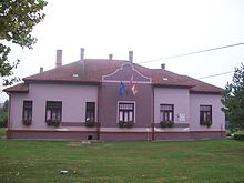
Veľká nad Ipľom
| Veľká nad Ipľom | ||
|---|---|---|
| coat of arms | map | |

|
|
|
| Basic data | ||
| State : | Slovakia | |
| Kraj : | Banskobystrický kraj | |
| Okres : | Lučenec | |
| Region : | Poiplie | |
| Area : | 24.420 km² | |
| Residents : | 921 (Dec. 31, 2019) | |
| Population density : | 38 inhabitants per km² | |
| Height : | 180 m nm | |
| Postal code : | 985 32 | |
| Telephone code : | 0 47 | |
| Geographic location : | 48 ° 16 ' N , 19 ° 37' E | |
| License plate : | LC | |
| Kód obce : | 511994 | |
| structure | ||
| Community type : | local community | |
| Administration (as of November 2018) | ||
| Mayor : | Gabriel Rácz | |
| Address: | Obecný úrad Veľká nad Ipľom č. 86 985 32 Veľká nad Ipľom |
|
| Website: | www.velkanadiplom.sk | |
| Statistics information on statistics.sk | ||
Veľká nad Ipľom (1927–1973 "Veliká nad Ipľom" - until 1927 "Veliká"; Hungarian Vilke ) is a municipality in southern Slovakia with 921 inhabitants (as of December 31, 2019). It belongs to the Okres Lučenec , a district of the Banskobystrický kraj , and is also part of the traditional Novohrad landscape .
geography
The municipality is located in the southwest of the Lučenská kotlina basin , part of the larger Juhoslovenská kotlina unit , on both sides of the Mašková brook . Not far from the village flows the Ipe Ortes , which marks the border with Hungary from here . The center of the village lies at an altitude of 180 m nm and is eight kilometers from Lučenec .
Neighboring communities are Jelšovec in the north, Panické Dravce in the northeast, Kalonda in the east, Ipolytarnóc (H) in the south, Trenč in the southwest, Ľuboriečka in the west and Ľuboreč and Halič in the northwest.
history
Veľká nad Iplom was first mentioned in writing in 1238 as Vilika . In the late Middle Ages it was one of the most important places in Neograd County and at times had city rights. In the 16th century the settlement came under the dominion of Šomoška Castle , between 1554 and 1593 it was part of the Ottoman Empire and was devastated during the Turkish wars of the 17th century. After 1680 the village was rebuilt and until 1848, as in the 17th century, belonged to the Forgách family . In 1730 the whole place burned down. In 1828 there were 107 houses and 793 inhabitants, who mainly practiced agriculture. In 1841 there was a modern sugar factory in the village.
Until 1918/1919 the place in Neograd County belonged to the Kingdom of Hungary and then came to Czechoslovakia or now Slovakia. Due to the First Vienna Arbitration Award , he was once again part of Hungary from 1938 to 1945.
From 1973 to 1990 the neighboring town of Trenč was part of the municipality.
population
According to the 2011 census, Veľká nad Ipľom had 947 inhabitants, of which 471 were Slovaks, 330 Magyars, 71 Roma, 3 Czechs and 1 Bulgarian and 1 German. 1 resident indicated a different ethnic group and 69 residents gave no information about the ethnic group. 670 inhabitants supported the Roman Catholic Church, 74 inhabitants joined the Evangelical Church AB, 31 inhabitants joined the Baptists, 5 inhabitants joined the Reformed Church, 4 inhabitants joined the Greek Catholic Church and 1 inhabitant joined the Orthodox Church; 2 residents professed a different denomination. 58 inhabitants were without a denomination and the denomination of 102 inhabitants was not determined.
Buildings
- Roman Catholic Church of All Saints in late Baroque style from 1762
traffic
Road No. 585 runs through Veľká nad Ipľom between Lučenec and Pôtor (via Dolná Strehová ).
The nearest train station with regular passenger traffic is Lučenec on the Salgótarján – Vrútky railway line (part of route 160 there).
Individual evidence
Web links
- Entry on e-obce.sk (Slovak)


