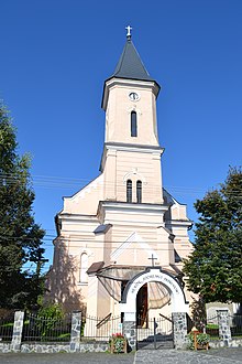
Radzovce
| Radzovce | ||
|---|---|---|
| coat of arms | map | |

|
|
|
| Basic data | ||
| State : | Slovakia | |
| Kraj : | Banskobystrický kraj | |
| Okres : | Lučenec | |
| Region : | Poiplie | |
| Area : | 18.789 km² | |
| Residents : | 1,556 (Dec. 31, 2019) | |
| Population density : | 83 inhabitants per km² | |
| Height : | 222 m nm | |
| Postal code : | 985 58 | |
| Telephone code : | 0 47 | |
| Geographic location : | 48 ° 13 ' N , 19 ° 50' E | |
| License plate : | LC | |
| Kód obce : | 511790 | |
| structure | ||
| Community type : | local community | |
| Administration (as of November 2018) | ||
| Mayor : | Péter György | |
| Address: | Obecný úrad Radzovce č. 506 985 58 Radzovce |
|
| Website: | www.radzovce.sk | |
| Statistics information on statistics.sk | ||
Radzovce (until 1948 “Ra „ovce” in Slovak; Ragyolc in Hungarian ) is a municipality in southern Slovakia with 1556 inhabitants (as of December 31, 2019). It belongs to the Okres Lučenec , a district of the Banskobystrický kraj and is part of the traditional Novohrad landscape .
geography
The municipality is located in the middle of the Cerová vrchovina mountainous region on the Belina brook ( Ipeľ river system ) near the Hungarian border. The town center is located at an altitude of 222 m nm and is 15 kilometers from Salgótarján (H) and 22 kilometers from Lučenec .
Neighboring municipalities are Biskupice and Belina in the north, Čamovce and Šurice in the east, Stará Bašta and Nová Bašta in the southeast, Šiatorská Bukovinka in the south, Čakanovce in the west and Ratka in the northeast.
history
The place was first mentioned in writing in 1246 as Ragiank and developed from an older settlement. He belonged to different sexes, including Ragyóczy in the 14th-16th centuries . Century. In modern times there was a split into two places called Egyházasragyolcz and Kápolnásragyolcz , which had to pay tribute to the Ottoman Empire (Sandschak Szécsény ) for several years . After 1594 the first-named place went under, in the 1680s the remaining place was depopulated, and most of the inhabitants did not return until around 1698. In 1828 there were 69 houses and 599 inhabitants who were employed in agriculture and as shepherds. In the 19th century there were basalt and trachyte quarries, as well as a hard coal mine. The mining activity came to a standstill after 1945.
The place in Neograd County belonged to the Kingdom of Hungary until 1918/1919 and then came to Czechoslovakia and Slovakia. 1938-1945 he was again in Hungary due to the First Vienna Arbitration . In 1959 the area of today's Šiatorská Bukovinka municipality was split from Radzovce.
population
According to the 2011 census, Radzovce had 1574 inhabitants, of which 1059 were Magyars, 404 Slovaks, 41 Roma, four Czechs and one Jew. 65 residents did not answer. 1357 residents professed to the Roman Catholic Church, 18 residents to the Evangelist Church, 12 residents to the Evangelical Church AB, six residents to the Evangelical Methodist Church, five residents each to the Seventh-day Adventists and the Old Catholic Church, four residents to the Reformed Church Church, three residents to the Jehovah's Witnesses and one resident to the Czechoslovak-Hussite Church; nine residents professed a different denomination. 74 inhabitants were without a denomination and the denomination of 80 inhabitants was not determined.
Buildings
- Roman Catholic Church of the Queen of Mary from 1913
- Art Nouveau country house from 1894
Individual evidence
- ↑ 2011 census by ethnicity (Slovak) ( Memento from October 6, 2014 in the Internet Archive )
- ↑ 2011 census by denomination (Slovak) ( Memento from September 7, 2012 in the Internet Archive )
Web links
- Entry on e-obce.sk (Slovak)

