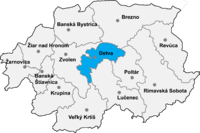
Okres Detva
| Overview maps | |
|---|---|

|

|
| Basic data Okres Detva | |
| Kraj : | Banskobystrický kraj |
| Area : | 449.19 km² |
| Residents : | 31,967 (December 31, 2019) |
| Population density : | 71.2 inhabitants / km² |
| License plate : | DT |
| District code: | 604 |
| Administrative division | |
| Cities: | 2 |
| Municipalities (excluding cities): | 13 |
| Statistics information about the Okres on statistics.sk | |
The detva district is an administrative unit in the means slowakei square kilometers with 32,722 inhabitants (2013) and an area of 449.2.
Historically, the district is mostly in the former Sohl county , a smaller part in the east around the town of Látky , in the southeast around Podkriváň and in the south around Horný Tisovník belongs to the former Nógrád county (see also the list of historical counties of Hungary ).
Cities
Communities
- Detvianska Huta
- Dúbravy
- Horný Tisovník
- Klokoč
- Korytárky
- Kriváň
- Látky
- Podkriváň
- Slatinské Lazy
- Stará Huta
- Stožok
- Vígľaš
- Vígľašská Huta-Kalinka
The district office is in Zvolen , a branch in Detva .
Culture
In the article Protected objects in the Okres Detva you can find about the objects protected by the Slovakian Monument Office in the Okres.
Web links
Commons : Pictures and Documents for Okres - Collection of pictures, videos and audio files