Chepén
| Chepén | |
|---|---|
|
Coordinates: 7 ° 14 ′ S , 79 ° 26 ′ W
Chepén on the map of Peru
|
|
| Basic data | |
| Country | Peru |
| region | La Libertad |
| province | Chepén |
| City foundation | 1785 |
| Residents | 37,466 (2017) |
| City insignia | |
| Detailed data | |
| height | 131 m |
| Time zone | UTC -5 |
| City Presidency | María del Carmen Cubas Cáceres (2019-2022) |
| Website | |
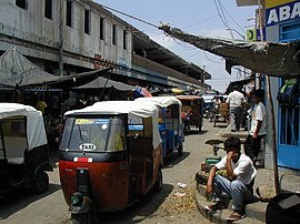
| Market in Chepén | |
Chepén is the capital of the Chepén Province in the La Libertad region in northwestern Peru . In the 2017 census, the population was 37,466. 10 years earlier this was 36,770. The city is the administrative seat of the district of the same name . The name of the city is derived from Francisco Chepén, a cacique of the Moche culture . Irrigated agriculture and rice cultivation are practiced in the vicinity of the city.
Geographical location
Chepén is located at the foot of an isolated barren hill in the arid coastal desert of northwestern Peru at an altitude of 131 m , about 20 km from the sea. On the hill there are ruins and remains of pre-Columbian walls where pottery and tombs have been found. The city of Chepén is located on the Panamericana Norte , about 130 km north of the city of Trujillo . The cities of Guadalupe , San Pedro de Lloc and Pacasmayo are in the vicinity .
Individual evidence
- ↑ a b PERU: La Libertad Region - Provinces & Places . www.citypopulation.de. Retrieved January 12, 2020.


