
Chesil Beach
.jpg)
Chesil Beach (sometimes Chesil Bank ) is a coastal formation in Dorset , England . The formation extends over 18 miles from West Bay (formerly Bridport Harbor) to Chiswell on the Isle of Portland . It connects the Isle of Portland with the mainland near Weymouth . The formation is 200 m wide and 15 m high and protects the towns of Weymouth and Chiswell against the main wind and wave direction. West Bay to the vicinity of Abbotsbury the Chesil Beach runs along the cliffs, then Chesil Beach separates one with brackish water filled lagoon from, called "The Fleet". Chesil Beach and The Fleet are part of the Jurassic Coast and thus also UNESCO World Heritage Sites .
history
Chesil Beach is completely covered with pebbles and hence the name is derived from the Old English ceoseol or cisel , which means something like gravel. The size of the stones varies over the entire formation. At West Bay the stones are only about the size of a pea, while at the Isle of Portland they are the size of an orange.
Much has been argued about the formation of the formation and the fact that it is covered in gravel leads to it being viewed as a raffle . The stones would have come from gravel deposits either at Budleigh Salterton or the Isle of Portland. However, geomorphological studies have now found a different explanation for the formation and structure of the formation. An ice age that began 125,000 years ago led to a drop in sea level, which until then was roughly at today's level. The erosion of the coast that already existed at that time was no longer carried away by the sea, but rather accumulated. When, after about 100,000 years, the sea level rose again because the ice receded, a large barrier of rubble had been deposited, which was meanwhile also overgrown, the water could now only remove and distribute this embankment very slowly, which is the current characteristic of the formation explains that it runs too straight along the coast for a classic raffle.
Chesil Beach in World War II
The thin settlement of the surrounding area and the proximity to the naval base in Portland Harbor made Chesil Beach an ideal military training ground during the war. Bombs for Operation Chastise , which destroyed dams in Germany, were tested in the Fleet Lagune .
gallery


Pebbles on Chesil Beach at Chesil Cove
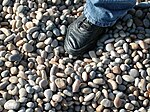
A shoe as a size comparison for the gravel on the Isle of Portland


Individual evidence
- ↑ A comprehensive overview is given by WJ Arkell, "The geology of the country around Weymouth, Swanage, Corfe and Lulworth," Memoirs of the Geological Survey of Great Britain , 1947, and later in abbreviated form: AP Carr and MWL Blackley, "Investigations Bearing on the Age and Development of Chesil Beach, Dorset, and the Associated Area, "Transactions of the Institute of British Geographers, No. 58 (March 1973) pp. 99-111.
- ^ Jurassic Coast: - Chesil Beach -Finest barrier beach in Europe. ( Memento of the original from December 31, 2009 in the Internet Archive ) Info: The archive link was automatically inserted and not yet checked. Please check the original and archive link according to the instructions and then remove this notice. Official website of the Jurassic Coast.
Coordinates: 50 ° 36 ′ 14 " N , 2 ° 30 ′ 58" W.