Chihuahua (Uruguay)
| Chihuahua | ||
|---|---|---|
|
Coordinates: 34 ° 52 ′ S , 55 ° 5 ′ W Chihuahua on the map of Uruguay
|
||
| Basic data | ||
| Country | Uruguay | |
| Department | Maldonado | |
| Residents | 37 (2011) | |
| Detailed data | ||
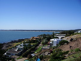
| View from Punta Ballena (foreground) to the Río de la Plata in front of Chihuahua | ||
| View from Casapueblo to Portezuelo / Ocean Park / Chihuahua (coastal strip on the horizon) | ||
Chihuahua is a locality in Uruguay .
geography
It is located in the Maldonado Department in Sector 1 on the coast of the Río de la Plata . Chihuahua is a few kilometers west of the department capital Maldonado and borders Punta Ballena to the east . The next location to the west is Ocean Park . The Arroyo El Potrero flows into the west of the village , while the Arboretum Lussich and Laguna del Sauce are located in the northeast and north .
Infrastructure
traffic
The Ruta 10 , the extension of the Ruta Interbalnearia , runs through Chihuahua . To the north is the Capitán de Corbeta Carlos A. Curbelo airport .
Residents
Chihuahua had 37 inhabitants in 2011, 14 of them male and 23 female.
| year | Residents |
|---|---|
| 1963 | - |
| 1975 | 0 |
| 1985 | 0 |
| 1996 | 7th |
| 2004 | 8th |
| 2011 | 37 |
Source: Instituto Nacional de Estadística de Uruguay
Web links
- City map of Chihuahua (PDF; 217 kB)
Individual evidence
- ↑ Statistical data ( memento of September 7, 2012 in the Internet Archive ) of the Instituto Nacional de Estadística de Uruguay , accessed on September 27, 2012
- ↑ Statistical data of the Instituto Nacional de Estadística de Uruguay 1963–1996 (DOC; 176 kB)
- ↑ Statistical data from the Instituto Nacional de Estadística de Uruguay 2004 as an xls file ( Memento from March 9, 2013 in the Internet Archive )


