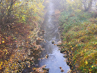
Chimlibach
|
Chimlibach Dorfbach |
||
|
Chimlibach just before the mouth |
||
| Data | ||
| Water code | CH : 608 | |
| location | Switzerland | |
| River system | Rhine | |
| Drain over | Glatt → Rhine → North Sea | |
| source | near Volketswil 47 ° 23 ′ 17 ″ N , 8 ° 42 ′ 0 ″ E |
|
| Source height | 475 m above sea level M. | |
| muzzle | near Schwerzenbach in the Glatt coordinates: 47 ° 22 '48 " N , 8 ° 38' 43" E ; CH1903: 691 115 / 248380 47 ° 22 '48 " N , 8 ° 38' 43" O |
|
| Mouth height | 435 m above sea level M. | |
| Height difference | 40 m | |
| Bottom slope | 6.5 ‰ | |
| length | 6.2 km | |
| Catchment area | 12.6 km² | |
| Discharge at the estuary A Eo : 12.6 km² |
MQ Mq |
260 l / s 20.6 l / (s km²) |
| Communities | Volketswil , Schwerzenbach | |
The Chimlibach (in the upper reaches also Dorfbach ) is an approximately six kilometers long right tributary of the Glatt in the Swiss canton of Zurich . It flows through the communities of Volketswil and Schwerzenbach in the overlapping regions of Oberland and Glatttal .
It is the first important tributary of the Glatt after the outflow from the Greifensee , which is only about 1.1 kilometers upstream from the mouth of the Chimlibach.
geography
course
The Chimlibach rises convoluted at 475 m above sea level. M. as a village stream in the Tonwisen corridor a little east of the Volketswil settlement area and only a little south of the source of the Chriesbach . After a short walk to the northwest, it reaches Volketswil and now follows the Zentralstrasse underground until shortly after the confluence with the Poststrasse . The stream now turns to the southwest and for the first time flows openly for around 10 meters. After crossing under Sigristengasse there is another short, open section where a flood relief channel branches off, which feeds the ponds in Griespark .
This is followed by longer open sections through the southern part of Volketswil, before another relief canal branches off at Kirchweg , which flows into the Guntenbach at Zimikon . It flows past the Neuwies cemetery and a little later reaches the Griespark . He now passes the two ponds and is overtaken again from the sports facility. It runs above Zimikon and reappears in the Tannboden district near Hegnau . Settlements and a larger allotment garden follow on the left , while agriculture and sometimes industry can be found on the right bank. After a short run, the stream turns south and forms the municipal boundary between Volketswil and Schwerzenbach.
Only shortly afterwards does it penetrate completely into built-up areas, in which it mostly flows openly. It now runs to the southeast, before making a larger curve to the southwest around the Schwerzenbacher Quartier Gferch . After the confluence of the most important tributary, the Guntenbach , and crossing under the railroad tracks, it passes over completely to Schwerzenbacher municipality area. It is now bordered on the right by fields that are completely enclosed by the settlement area, and from the left takes on the Zimikerriedgraben , which rises from the golf course. In doing so, he passes the Oberholz cemetery on the left bank , where he makes a small curve to the south, before flowing shortly to the northwest. It now flows through another strip of settlement on Dorfstrasse before turning to the southwest after the Schlösseri tennis facility . Shortly afterwards the Chimlibach flows out at 425 m above sea level. M. across from Fällanden in the upper reaches of the Glatt.
Catchment area
The 12.6 km² catchment area consists of 44.5% built-up area, 39.5% agricultural area and 15.9% near-natural area and forest. The highest point is 589 m above sea level. M. in Chammerholz between Freudwil and Wermatswil , the average altitude is 483 m above sea level. M.
In the north lies the catchment area of the Kempt and the Chriesbach and in the south that of the Werrikerbach .
Web links
- Course of the Chimlibach on swisstopo
- Course of the Chimlibach on GIS Zurich
Individual evidence
- ↑ a b individual records of the geographic information system of the canton of Zurich
- ↑ a b Geoserver of the Swiss Federal Administration ( information )
- ↑ a b Modeled mean annual discharge. In: Topographical catchment areas of Swiss waters: area outlets. Retrieved November 12, 2015 .

