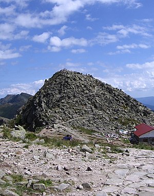
Chopok
| Chopok | ||
|---|---|---|
| height | 2023.6 m nm | |
| location | Slovakia | |
| Mountains | Low Tatras , Carpathian Mountains | |
| Coordinates | 48 ° 56 '35 " N , 19 ° 35' 30" E | |
|
|
||
At 2023.6 m, the Chopok is the third highest peak in the Low Tatras after the ierumbier (2043.4 m) and the Štiavnica (2025.3 m) . It lies between the Dereše and Konské mountains . Its north side is characterized by stone walls and deeply cut gorges, which merge to the northeast into the basin of the Luková valley, where moraine remnants have deposited and also formed a small lake, while the south side has slopes strewn with boulders.
You can reach the Chopok on the blue marked path from the Luková valley (60 min there, 45 min back). You can get there by cable car from the Koliesko refuge in the Demänovská Dolina valley . Another possibility is from the south: on foot on the yellow marked path from the Hotel Kosodrevina in the Bystra valley (2 hours there, one and a half hours back), which in turn can be reached by cable car from the Hotel Srdiečko. The mountain hut Kamenná chata pod chopkom (German for "Chopok stone hut") as well as a television transmitter and a meteorological station are located on the summit of Chopok .


