Christertshofen
|
Christertshofen
Market book
Coordinates: 48 ° 13 ′ 48 ″ N , 10 ° 13 ′ 30 ″ E
|
||
|---|---|---|
| Incorporation : | May 1, 1978 | |
| Postal code : | 89290 | |
| Area code : | 07343 | |
|
Location of Christertshofen in Bavaria |
||
Christertshofen is a district of the Buch market in the Swabian district of Neu-Ulm .
geography
Christertshofen is located in the valley of the Vorderen Huttenbach, which joins the Hinterer Huttenbach to the Osterbach (Biber) about four kilometers east of the main town near the hamlet of Friesenhofen .
history
The -hofen places indicate an early medieval settlement by the Alemanni. Originally owned by the Lords of Biberegg-Roggenburg Chris tert Hofen went to their extinction in the you founded the monastery Roggenburg over. Christertshofen has been Bavarian since 1805.
On May 1, 1978, the previously independent community of Christertshofen was incorporated into Markt Buch.
Attractions
- Catholic parish church St. Georg with frescoes by Konrad Huber and late Gothic Lamentation of Christ by Niklaus Weckmann
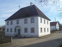
- Rectory based on a design by Joseph Dossenberger
- Pilgrimage church Waldreichenbach with an associated restaurant, one kilometer to the east
On the way to Waldreichenbach there is a war memorial with the inscription: During the Second World War (1939-1945), 2 German soldiers died here on October 25, 1944 - KSV Christertshofen 1986
Web links
Individual evidence
- ↑ Sarah Hadry "On the History of Buchs and Surroundings"
- ^ Federal Statistical Office (ed.): Historical municipality directory for the Federal Republic of Germany. Name, border and key number changes in municipalities, counties and administrative districts from May 27, 1970 to December 31, 1982 . W. Kohlhammer GmbH, Stuttgart and Mainz 1983, ISBN 3-17-003263-1 , p. 790 .


