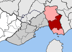
Chrysoupoli (municipality)
|
Chrysoupoli parish Δημοτική Ενότητα Χρυσούπολης (Χρυσούπολη) |
||
|---|---|---|
|
|
||
| Basic data | ||
| State : |
|
|
| Region : |
East Macedonia and Thrace
|
|
| Regional District : | Kavala | |
| Municipality : | Nestos | |
| Geographic coordinates : | 40 ° 59 ′ N , 24 ° 38 ′ E | |
| Height above d. M .: | 35 m (average) |
|
| Area : | 245.181 km² | |
| Residents : | 16,004 (2011) | |
| Population density : | 65.3 inhabitants / km² | |
| Code No .: | 050201 | |
| Structure: |
1 city district 12 local communities |
|
| Located in Nestos Municipality and Kavala Regional District | ||
The municipality of Chrysoupoli ( Greek Δημοτική Ενότητα Χρυσούπολης Dimotiki Enotita Chrysoupolis ) is one of three municipal districts of the municipality of Nestos in the Greek region of East Macedonia and Thrace . It emerged from the municipality of the same name as part of the 2010 administrative reform and is subdivided into the Chrysoupoli district and twelve local communities.
location
The municipality occupies an area of 245,181 square kilometers between the municipal districts of Orino in the north and Keramoti in the south. In the east, the Nestos forms the natural border with the municipality of Topiros , the municipality of Kavala and the Gulf of Kavala border in the west.
structure
The municipality of Chrysoupoli ( Dimos Chrysoupoleos Δήμος Χρσουπόλεως) was from 1997 to 2010 a municipality of the then Greek prefecture of Kavala with the administrative seat in Chrysoupoli . It was created as a result of the municipal reform in 1997 from the merger of the Chrysoupoli municipality, which had existed since 1946, with twelve rural municipalities. With the administrative reform in 2010 , Chrysoupoli was merged with Keramoti and Topiros to form the new municipality of Nestos and has since formed a municipality there. This is subdivided into the municipality of Chrysoupoli and twelve local communities.
| District local community |
Greek name | code | Area (km²) | 2001 residents | Residents 2011 | Villages and settlements |
|---|---|---|---|---|---|---|
| Chrysoupoli | Δημοτική Κοινότητα Χρυσούπολης | 05020101 | 46.890 | 8004 | 8885 | Chrysoupoli |
| Avramylia | Τοπική Κοινότητα Αβραμυλιάς | 05020102 | 8,498 | 48 | 64 | Avramylia, Damaskinia |
| Gerondas | Τοπική Κοινότητα Γέροντα | 05020103 | 14,847 | 450 | 468 | Gerondas |
| Gravouna | Τοπική Κοινότητα Γραβούνης | 05020104 | 9.498 | 849 | 737 | Gravouna |
| Dialect | Τοπική Κοινότητα Διαλεκτού | 05020105 | 10.148 | 178 | 143 | Dialecto, eclectic, krini |
| Eratino | Τοπική Κοινότητα Ερατεινού | 05020106 | 22,120 | 883 | 649 | Eratino |
| Zarkadia | Τοπική Κοινότητα Ζαρκαδιάς | 05020107 | 8,998 | 594 | 671 | Ekali, Zarkadia |
| Xeria | Τοπική Κοινότητα Ξεριά | 05020108 | 22,545 | 503 | 468 | Neos Xerias |
| Paradisos | Τοπική Κοινότητα Παραδείσου | 05020109 | 11,047 | 429 | 216 | Paradisos |
| Perni | Τοπική Κοινότητα Πέρνης | 05020110 | 26.209 | 941 | 897 | Perni |
| Petropigi | Τοπική Κοινότητα Πετροπηγής | 05020111 | 19,496 | 530 | 522 | Petropigi |
| Pondolivado | Τοπική Κοινότητα Ποντολιβάδου | 05020112 | 26.739 | 476 | 465 | Ano Pondolivado, Nea Komi, Pondolivado |
| Chrysochori | Τοπική Κοινότητα Χρυσοχωρίου | 05020113 | 18,146 | 1793 | 1818 | Chrysochori |
| total | 050201 | 245.181 | 15,678 | 16.004 | ||
Individual evidence
- ↑ Results of the 2011 census, Greek Statistical Office (ΕΛ.ΣΤΑΤ) ( Memento from June 27, 2015 in the Internet Archive ) (Excel document, 2.6 MB)
- ↑ Κεντρική Ένωση Δήμων και Κοινοτήτων Ελλάδας (ΚΕΔΚΕ) Ελληνική Εταιρία Τοπικής Ανάπτυξης και Αυτοδιοίκησης (ΕΕΤΑΑ) (ed.): Λεξικό Διοικητικών Μεταβολών των Δήμων και Κοινοτήτων (1912-2001). 2 (Τόμος Β, λ – ω), Athens 2002, ISBN 960-7509-47-1 , p. 574 f

