
Nestos (municipality)
|
Nestos community Δήμος Νέστου (Νέστος) |
|||
|---|---|---|---|
|
|||
| Basic data | |||
| State : |
|
||
| Region : | East Macedonia and Thrace | ||
| Regional District : | Kavala | ||
| Geographic coordinates : | 40 ° 59 ′ N , 24 ° 42 ′ E | ||
| Area : | 674.56 km² | ||
| Residents : | 22,331 (2011) | ||
| Population density : | 33.1 inhabitants / km² | ||
| Seat: | Chrysoupoli | ||
| LAU-1 code no .: | |||
| Districts : | 3 municipal districts | ||
| Local self-government : |
2 city districts 23 local communities |
||
| Website: | www.nestos.gr | ||
| Location in the region of East Macedonia and Thrace | |||
 |
|||

Nestos ( Greek Νέστος ( m. Sg. )) Is a municipality in the east of the Greek region of Macedonia and has its seat in the small town of Chrysoupoli , in which 8885 of the approximately 22,000 inhabitants of the municipality live. Other larger settlements are Chrysochori (1818 Ew.), Keramoti (1438 Ew.) And Nea Karya (1426 Ew.).
The villages and settlements of Nestos were administered in the late Ottoman Empire in Kaza Sarışaban by today's Chrysoupoli (then in Greek Sari Saban Σαρί Σαμπάν, Slavic Sari Schaban Сари Шабанъ), which was followed in the Kingdom of Greece by the province of Nestos as an administrative unit after 1913 . From 1997 to 2010, when the province was abolished, the villages formed three parishes; they were merged in 2011 to form the parish of Nestos.
geography
Nestos lies on the right, western bank of the lower reaches of the Nestos River , which is the border river between the historical regions of Macedonia and Thrace . The north of the municipality has a share of the southern Rhodope Mountains , the Nestos flows through a gorge that separates the Lekani Mountains west from the Achlat Tsal in the northeast. The northeastern neighboring community is Xanthi , to the south of which Topiros joins. The highest point of the municipality is the summit of Lekani ( 1298 m ) on the north-western border with Paranesti municipality . This is where the Xiropotamos rises, which marks the border to neighboring Kavala to the west .
About the southern half of the municipality consists of the western alluvial land of the Nestos, which flows here in an extensive delta into the Aegean Sea that borders the municipality to the south . The island of Thasopoula is located directly off the south coast , around five kilometers south of the port of Keramoti , across the Strait of Thasos, is the island of Thasos . The southwest coast, which is characterized by small lagoons , borders the bay of Kavala.

View from the southwest of the Lekani Mountains
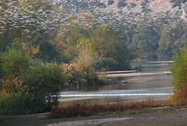
The Nestos Valley in the east of the municipality

Keramoti

View from Thasos to Thasopoula and the coast at Keramoti


population
The Nestos area was heavily affected by the population exchanges between Greece and Turkey after 1923. In a Salname , which the Greek Ministry of War also published in a translation in 1910, 21,289 Muslims, 481 Greek Orthodox, 266 members of the Bulgarian Exarchate and 68 Christian Roma were counted in Kaza Sarışaban . After the population exchange, the Greek census of 1928 also documented the place of birth and mother tongue of the inhabitants. According to this census, 20,546 people lived in Nestos Province, of whom 4,954 were born in Greece and 15,592 were born outside Greece. The main mother tongues were Greek (17,986 people) and Turkish (2403), as well as Romany (56), Armenian (40), Spanish (22) and Koutzovlach (14), and only one resident was recorded as speaking "Macedonoslav".
traffic
Kavala Airport is located in the municipality . The southern part of the municipality is well connected to the Greek highway network through the Greek A2 ; small country roads open up the villages in the mountains. The Thessaloniki – Edirne railway bypasses the municipality to the north, there is no connection. The port of Keramoti is important for ferry traffic with the island of Thasos.
Community structure
Until 1997 the present districts were independent communities in the Nestos province of the Kavala prefecture . In 1997 they were merged into three parishes; these three municipalities were merged into the new municipality of Nestos during the 2010 administrative reform .
The communities that existed until 1997 have had the status of urban districts (Ez. Gr. Dimotiki kinotita δημοτική κοινότητα) or local communities ( topiki kinotita τοπική κοινότητα) and elect their own local representatives. The population figures come from the results of the 2011 census.

- Chrysoupoli parish - Δημοτική Ενότητα Χρυσούπολης - 16.004
- Chrysoupoli district - Δημοτική Κοινότητα Χρυσούπολης - Χρυσούπολη - 8,885
- Local community Avramylia - Τοπική Κοινότητα Αβραμυλιάς - 65
- Avramylia - Αβραμυλιά - 46
- Damaskinia - Δαμασκηνιά - 19
- Local community Chrysochori - Τοπική Κοινότητα Χρυσοχωρίου - Χρυσοχώρι - 1.818
- Local community dialecto - Τοπική Κοινότητα Διαλεκτού - 143
- Dialecto - Διαλεκτό - 107
- Eclecto - Εκλεκτό - 2
- Krini - Κρήνη - 34
- Local community Eratino - Τοπική Κοινότητα Ερατεινού - Ερατεινό - 649
- Local community Gerondas - Τοπική Κοινότητα Γέροντα - Γέροντας - 468
- Local community Gravouna - Τοπική Κοινότητα Γραβούνης - Γραβούνα - 737
- Local community Neos Xerias - Τοπική Κοινότητα Ξεριά - Νέος Ξεριάς - 468
- Local community Paradisos - Τοπική Κοινότητα Παραδείσου - Παράδεισος - 216
- Local community Perni - Τοπική Κοινότητα Πέρνης - Πέρνη - 897
- Local community Petropigi - Τοπική Κοινότητα Πετροπηγής - Πετροπηγή - 522
- Local community Pondolivado - Τοπική Κοινότητα Ποντολιβάδου - 465
- Ano Pondolivado - Άνω Ποντολίβαδο - 120
- Nea Komi - Νέα Κώμη - 63
- Pondolivado - Ποντολίβαδο - 282
- Local community Zarkadia - Τοπική Κοινότητα Ζαρκαδιάς - 671
- Ekali - Εκάλη - 73
- Zarkadia - Ζαρκαδιά - 598

- Keramoti municipality - Δημοτική Ενότητα Κεραμωτής - 5.115
- Keramoti district - Δημοτική Κοινότητα Κεραμωτής - 2.056
- Chaidefto - Χαϊδευτό - 388
- Keramoti - Κεραμωτή - 1.438
- Monastiraki - Μοναστηράκι - 230
- Local community Agiasma - Τοπική Κοινότητα Αγιάσματος - 863
- Agiasma - Αγίασμα - 843
- Paralia Agiasmatos - Παραλία Αγιάσματος - 20
- Local community Nea Karya - Τοπική Κοινότητα Νέας Καρυάς - Νέα Καρυά - 1.426
- Local community Piges - Τοπική Κοινότητα Πηγών - Πηγές - 770
- Keramoti district - Δημοτική Κοινότητα Κεραμωτής - 2.056

- Orino municipality - Δημοτική Ενότητα Ορεινού - Ορεινό - 1.212
- Local community Agios Kosmas - Τοπική Κοινότητα Αγίου Κοσμά - 35
- Agios Kosmas - Άγιος Κοσμάς - 20
- Skopos - Σκοπός - 15
- Local community Dipotamos - Τοπική Κοινότητα Διποτάμου - Διπόταμος - 45
- Local community Dysvato - Τοπική Κοινότητα Δυσβάτου - 28
- Dysvato - Δύσβατο - 9
- Stegno - Στεγνό - 19
- Local community Elafochori - Τοπική Κοινότητα Ελαφοχωρίου - Ελαφοχώρι - 62
- Local community Kechrokambos - Τοπική Κοινότητα Κεχροκάμπου - Κεχρόκαμπος - 359
- Local community Lekani - Τοπική Κοινότητα Λεκάνης - Λεκάνη - 485
- Local community Makrychori - Τοπική Κοινότητα Μακρυχωρίου - 120
- Kryoneri - Κρυονέρι - 13
- Makrychori - Μακρυχώρι - 84
- Nikites - Νικητές - 12
- Platania - Πλατανιά - 11
- Local community Platamonas - Τοπική Κοινότητα Πλαταμώνος - Πλαταμώνας - 78
- Local community Agios Kosmas - Τοπική Κοινότητα Αγίου Κοσμά - 35
Individual evidence
- ↑ a b Results of the 2011 census at the National Statistical Service of Greece (ΕΛ.ΣΤΑΤ) ( Memento from June 27, 2015 in the Internet Archive ) (Excel document, 2.6 MB)
- ↑ Comprehensive collection of sources on the population of the villages around Sarışaban by Dimitri Lithoxoou, accessed on July 27, 2014 (Greek)
- ↑ Results of the Greek population censuses from 1879–2001, available as PDF under http://dlib.statistics.gr/portal/page/portal/ESYE/categoryyears?p_cat=10007862&p_topic=10007862