Topiros
|
Topiros municipality Δήμος Τοπείρου (Τόπειρος) |
||
|---|---|---|
|
|
||
| Basic data | ||
| State : |
|
|
| Region : | East Macedonia and Thrace | |
| Regional District : | Xanthi | |
| Geographic coordinates : | 41 ° 0 ′ N , 24 ° 49 ′ E | |
| Area : | 312.493 km² | |
| Residents : | 11,544 (2011) | |
| Population density : | 36.9 inhabitants / km² | |
| Community logo: | ||
| Seat: | Evlalo | |
| LAU-1 code no .: | ||
| Districts : | no | |
| Local self-government : |
2 city districts 6 local communities |
|
| Website: | www.topiros.gr | |
| Location in the region of East Macedonia and Thrace | ||
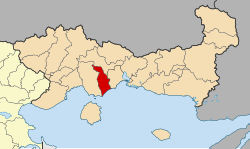
Topiros ( Greek Τόπειρος ( m. Sg. )) Is a Greek community in western Thrace . It was formed in 1997 from eight small communities and named after an ancient city of the same name, which was mentioned by ancient historians and is located in the area of the municipality. The municipality comprises 31 inhabited villages and settlements, its administrative seat is in Evlalo (922 inhabitants), the largest settlements are Iliokendima (1405 inhabitants) and Avato (1078 inhabitants).
geography
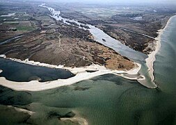
Topiros occupies the left, eastern part of the Nestos Delta and a small area upstream on the left bank of the Nestos Gorge. The mountainous part of the municipality is uninhabited today, it is located in the Eastern Rhodope Mountains in the western foothills of the mountain Achlat Tsal or Achladovouni ( 1970 m ). Neighboring communities across the river are the Macedonian community of Nestos , to the north and northeast Xanthi and east Avdira .
An extensive alluvial forest , the 'Great Forest' ( Greek Μέγα Δάσος Mega Dasos , Turkish Koca Orman ), which is designated as a Ramsar area, extends near the mouth of the Nestos . With around 15 kilometers of coastline, Topiros borders the Aegean Sea in the south , and the flat sandy beach that lines the shore is used for tourism.
History and population
The area of Topiros had belonged to the Ottoman Empire since the 14th century and was mostly Muslim in its late period. The villages in Nahiye Çeleblü (later Ageli, meanwhile abandoned) in Kaza İskeçe des Sandschak Gümülcine were administered .
Together with the rest of Western Thrace, the area came to Greece in 1919 and after 1923 took in many Greek Orthodox refugees from Turkey. Nevertheless, the community still has a strong Turkish population, but there are no official figures relating to the community. The Greek state officially replaced the all Turkish names of the villages with Greek ones in 1920. So Toxotes a direct translation of the Turkish name Okçular (archers'). The area is affected by strong rural exodus, so some villages, especially in the north of the municipality, were abandoned in the second half of the 20th century.
A specialty in Topiros are the Muslim descendants of African slaves from the time of the Ottoman Empire, the so-called 'Black Greeks' (Μαύροι Έλληνες), whose ancestors came from Sudan . Less than a thousand of them still live in Avato and some surrounding villages.
The old mosque of Toxotes was set on fire by unknown persons on the day of the Greek parliamentary elections in 2004 and completely destroyed. After the reconstruction, new arson attacks followed in 2007 and 2009, which, however, caused far less damage.
economy
Topiros is characterized by agriculture. The area is one of the traditional tobacco growing areas of Greece. There is a sugar factory at Toxotes, which has only served as a packaging and collection center since 2006. There is a fish farming cooperative near the coast .
There is also a shortwave station of the Greek international broadcaster Voice of Greece near the Nestos estuary .
traffic
At the edge of the Rhodope Mountains, the Greek runs A 2 by the municipality.
The Thessaloniki – Alexandroupoli railway leaves the Nestos Valley in the municipality and continues via Toxotes to Xanthi, a few kilometers away .
The Kavala airport is not far in the western neighboring community Nestos.
sons and daughters of the town
- Member of Parliament Tsetin Mantatzi was born in 1970 in Orfano.
Community structure
The communities that existed until 1997 have had the status of urban districts (Ez. Gr. Dimotiki kinotita δημοτική κοινότητα) or local communities ( topiki kinotita τοπική κοινότητα) and elect their own local representatives. The population figures come from the results of the 2011 census. The Turkish names of the villages are also given in brackets.
- Evlalo District - Δημοτική Κοινότητα Ευλάλου - 4,985
- Dekarcho (Beyobası) - Δέκαρχο - 734
- Evlalo (İnhanlı) - Εύλαλο - 922
- Iliokendima (Gencerlı & Gütaslı) - Ηλιοκέντημα - 1.405
- Kremasti (Kurthasanlı) - Κρεμαστή - 382
- Kyrnos (Kırköy) - Κύρνος - 852
- Mikrochori - Μικροχώρι - 264
- Orfano (Öksüzlü) - Ορφανό - 317
- Paleo Olvio (Nuhullu) - Παλαιό Όλβιο - 109
- Toxotes Municipality - Δημοτική Κοινότητα Τοξοτών - 1,845
- Agios Athanasios - Άγιος Αθανάσιος - 239
- Kosmiti (Küçükosmanlı) - Κοσμητή - 51
- Mega Tymbano - Μέγα Τύμπανο - 299
- Micro Tymbano (Davutlu) - Μικρό Τύμπανο - 62
- Pimni (Çobanmahalle) - Ποίμνη - 44
- Semeli (Fecirli) - Σεμέλη - 27
- Thalassia (Denizli?) - Θαλασσιά - 304
- Toxotes (ocular) - Τοξότες - 819
- Local community Avato (Beyköy) - Τοπική Κοινότητα Αβάτου - Άβατο - 1.078
- Local community Galani (Çakırlı) - Τοπική Κοινότητα Γαλάνης - Γαλάνη - 108
- Local community Exochi - Τοπική Κοινότητα Εξοχής - 1.295
- Dafni - Δάφνη - 43
- Exochi (Üsekdere) - Εξοχή - 86
- Gizela (Karagözlü) - Γκιζέλα - 184
- Kossos (Köseçalı) - Κοσσός - 73
- Kypseli - Κυψέλη - 210
- Melissa - Μέλισσα - 345
- Nea Amisos (Alatçilar) - Νέα Αμισός - 188
- Vaniano (Balabanlı) - Βανιάνο - 166
- Local community Erasmio - Τοπική Κοινότητα Ερασμίου 1.268
- Dasochori - Δασοχώρι - 112
- Neo Erasmio - Νέο Εράσμιο - 865
- Paleo Erasmio (Taraşmanlı) - Παλαιό Εράσμιο - 291
- Radiostathmos ('radio station') - Ραδιοσταθμός - uninhabited
- Local community Mangana (Büyükosmanlı) - Τοπική Κοινότητα Μαγγάνων - Μάγγανα - 635
- Local community Olvio - Τοπική Κοινότητα Ολβίου - Όλβιον - 330
Individual evidence
- ↑ a b Results of the 2011 census. ( Memento from June 27, 2015 in the Internet Archive ) ( MS Excel ; 2.6 MB) National Statistical Service of Greece (ΕΛ.ΣΤΑΤ)
- ^ William Smith: Dictionary of Greek and Roman Geography, London 1854 (online)
- ↑ Portrait of abandoned settlements on the municipality's website
- ↑ Thede Kahl: Muslims in Northeast Greece . In: Erasmus office of the University of Münster (ed.): Colloquium Northeast Greece (Münster 1992–1997). Münster 1995, Volume 3, p. 113 ff. Thede 1995 - Muslims in Northeast Greece.pdf slawistik.uni-jena.de (PDF)
- ↑ Report on the website of the station NovaFM106 (Greek)
- ↑ Report on the website of the Greek daily newspaper Embros (Greek)
- ↑ Report ( Memento of the original from August 8, 2014 in the Internet Archive ) Info: The archive link was inserted automatically and has not yet been checked. Please check the original and archive link according to the instructions and then remove this notice. the Turkish daily newspaper Zaman (Turkish)
- ↑ Presentation of the Xanthi unit on the company's website (Greek)
- ^ List of Thracian renaming by Dimitri Lithoxoou according to Greek state documents , Türk. Orthography according to Osmanlı Belgerinde Batı Traya . Ankara 2009, devletarsivleri.gov.tr ( Memento of the original from August 8, 2014 in the Internet Archive ) Info: The archive link was inserted automatically and has not yet been checked. Please check the original and archive link according to the instructions and then remove this notice. (PDF; 34.1 MB)


