Lekani Mountains
| Lekani Mountains Όρη Λεκάνης |
||
|---|---|---|
| height | 1298 m | |
| location | North Greece | |
| Mountains | Greek Rhodope Mountains | |
| Coordinates | 41 ° 1 ′ 0 ″ N , 24 ° 30 ′ 0 ″ E | |
|
|
||
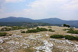
The Lekani Mountains ( Greek Όρη Λεκάνης Ori Lekanis ) are a mountain range in the southern Greek Rhodopes north to northeast of Kavala between the rivers Xiropotamos and Nestos . The highest peaks include Lekani (1298 m), Christos (1174 m) and Chalkero (841 m).
Mining and metal extraction
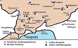
Geologically, the greater area of Palaia Kavala in the Lekani Mountains with the local mines and smelting sites of Zygos, Kastanies, Kryoneri, Giolia, Goritza, Makrovouni, Mandra Kari, Tria Karagatsia and Pistirma / Chalkero belongs to the southeastern part of the Greek Rhodope Mountains . Three types of ore bodies were mined here in antiquity :
- Iron-manganese ores in the carbonate rocks with gold contents up to 26 μg / g
- Lead-zinc and silver-rich iron-manganese ores are also found in the carbonate rocks , with silver contents up to 2500 μg / g
- Pyrite - arsenic gravel and pyrite copper gravel in the marble / gneiss contact area and in the gneiss itself, with gold contents of up to 38 μg / g.
The mineral inventory of the iron-manganese ores essentially consists of manganese and iron oxides, carbonates, arsenides , sulfides and various gangue materials. In the oxidation and sulphide ores of Palaia Kavala, silver-containing jarosite , pale ore , red ore , Freibergite , silver luster as well as native silver and gold were found.
One of the major gold mines investigated in 1996 in the mining area of Palaia Kavala is Mandra Kari ( 40 ° 58 ′ 0 ″ N , 24 ° 23 ′ 0 ″ E ). The mine layout shows a strongly branched route system. With many collapsed stretches, the total extent of the mine remains unexplored. There are three soles lying on top of each other. The stretches and widenings were cut with mallets and irons. The tunneling technology is similar to that of Laurion , Sifnos and Thasos. The rectangular cross-sections of the route with a height of 0.9 m and a width of 0.8 m are characteristic. The mining expansions reach up to 15 m in length, 10 m in width and 5 m in height.
The driving and mining method used in Mandra Kari was in the classical period in the 5th century BC. Common, from which it can be concluded that the mine was in operation at that time. Signs of an older, probably prehistoric, possibly Thracian mining activity could also be found in Mandra Kari.
The processing and extraction of the gold was carried out by washing out the softer ocher-like material, as well as by crushing, grinding and washing the hard iron ores and finally by melting the extracted heavy fractions.
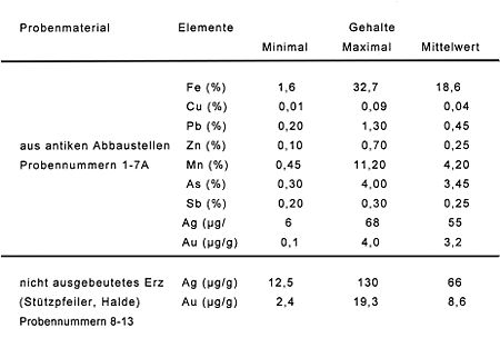
16 samples were taken from mining sites, pillars and dump material and analyzed. The silver and iron contents are low, the gold contents in the ore on average at 8.6 μg / g. From the analysis results it can be concluded that neither iron ore nor silver could be considered worthy of mining, but only gold could have been the target of mining. The gold content of the ores that were mined in antiquity may have been more than 4 μg / g.
Assuming an average gold content of 10 μg / g, 16,000 tons, i.e. around 6,000 cubic meters of ore, were mined annually. Even a mine like Mandra Kari cannot have produced such a production volume on its own. This requires an extensive mining area. Depending on the size, metal content and number of ancient mining sites and smelting slag, the entire area north to northeast of Neapolis / Kavala can be considered.
A central melting point in the area of Palaia Kavala can be found in the immediate vicinity of the Mandra Kari gold mine near Tria Karagatsia . This place is well suited for ore smelting because it is windy there and there are several water sources. About 50,000 tons of slag can be found on about five hectares. However, this is not gold, but lead-silver smelting, as the findings of lead slag and black lead show. A ceramic find gave a date of around 328 AD, thus proving a late Roman to early Byzantine lead-silver extraction at this point.
literature
- M. Vavelidis, G. Gialoglou, B. Melfos, G. Wagner: Gold mine in Palaea Kavala / Greece . In: Erzmetall , 09/1996, pp. 547–554, GDMB Society for Mining, Metallurgy, Raw Material and Environmental Technology , Clausthal-Zellerfeld


