Churchill Peninsula
| Churchill Peninsula | ||
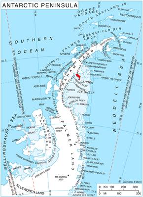
 Location of the Churchill Peninsula on the east coast of Graham Land |
||
| Geographical location | ||
|
|
||
| Coordinates | 66 ° 30 ′ S , 62 ° 45 ′ W | |
| location | Oscar II Coast , Graham Land , Antarctic Peninsula | |
| Waters 1 | Cabinet inlet | |
| Waters 2 | Adie inlet | |
| length | 48 km | |
The Churchill Peninsula is an icy peninsula on the border between the Foyn Coast and Oskar II Coast in Graham Land on the Antarctic Peninsula . It lies between the Cabinet Inlet and the Adie Inlet and extends 48 km in a southeast direction into the Weddell Sea .
Aerial photographs of the peninsula were taken during the Ronne Antarctic Research Expedition (1947-1948) and were mapped in 1947 by the Falkland Islands Dependencies Survey . It is named after the British statesman Winston Churchill (1874–1965).
Web links
- Churchill Peninsula in the Geographic Names Information System of the United States Geological Survey (English)
- Churchill Peninsula on geographic.org (English)
