
Les Gonds
| Les Gonds | ||
|---|---|---|
.svg)
|
|
|
| region | Nouvelle-Aquitaine | |
| Department | Charente-Maritime | |
| Arrondissement | Saintes | |
| Canton | Thénac | |
| Community association | Saintes | |
| Coordinates | 45 ° 43 ′ N , 0 ° 37 ′ W | |
| height | 2–20 m | |
| surface | 12.96 km 2 | |
| Residents | 1,726 (January 1, 2017) | |
| Population density | 133 inhabitants / km 2 | |
| Post Code | 17100 | |
| INSEE code | 17179 | |
| Website | www.lesgonds.fr | |
 Town Hall (Mairie) of Les Gonds |
||

Les Gonds is a French commune with 1,726 inhabitants (as of January 1 2017) in the department of Charente-Maritime in the region Nouvelle-Aquitaine . It belongs to the arrondissement of Saintes and the canton of Thénac (until 2015: canton of Saintes-Est ). The inhabitants are called Gontais (es) .
geography
Les Gonds is located about three kilometers south-southeast of Saintes . The Charente , into which the Seugne flows here, limits the municipality to the north. Les Gonds is surrounded by the neighboring communities of Saintes in the north and north-west, Chaniers in the east and north-east, Courcoury in the east, Berneuil in the south and south-east, Préguillac in the south and Thénac in the west and south-west.
Population development
| year | 1962 | 1968 | 1975 | 1982 | 1990 | 1999 | 2006 | 2013 |
| Residents | 807 | 846 | 869 | 1,028 | 1,129 | 1,241 | 1,645 | 1,609 |
| Source: Cassini and INSEE | ||||||||
Attractions
See also: List of Monuments historiques in Les Gonds
- Saint-Vivien church from the 12th century
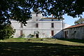
- Thérac Castle
- Les Pères dairy
- Crossroads

Saint Vivien Church

Thérac Castle
Les Pères dairy
_%C3%A9glise_01.JPG)


literature
- Le Patrimoine des Communes de la Charente-Maritime. Flohic Editions, Volume 2, Paris 2002, ISBN 2-84234-129-5 , pp. 994-995.