
La Chapelle-des-Pots
| La Chapelle-des-Pots | ||
|---|---|---|

|
|
|
| region | Nouvelle-Aquitaine | |
| Department | Charente-Maritime | |
| Arrondissement | Saintes | |
| Canton | Chaniers | |
| Community association | Saintes | |
| Coordinates | 45 ° 46 ′ N , 0 ° 32 ′ W | |
| height | 19-88 m | |
| surface | 10.27 km 2 | |
| Residents | 1,002 (January 1, 2017) | |
| Population density | 98 inhabitants / km 2 | |
| Post Code | 17100 | |
| INSEE code | 17089 | |
 Town hall (Mairie) of La Chapelle-des-Pots |
||

La Chapelle-des-Pots is a French commune with 1,002 inhabitants (as of January 1 2017) in the department of Charente-Maritime in the region Nouvelle-Aquitaine . It belongs to the Arrondissement Saintes and the Canton of Chaniers (until 2015: Canton Saintes-Est ). The inhabitants are called Chapelains .
geography

La Chapelle-des-Pots is about seven kilometers east-northeast of Saintes . La Chapelle-des-Pots is surrounded by the neighboring communities of Vénérand in the north, Saint-Césaire in the east and south-east, Chaniers in the south and Fontcouverte in the west.
Population development
| year | 1962 | 1968 | 1975 | 1982 | 1990 | 1999 | 2006 | 2017 |
| Residents | 510 | 550 | 694 | 823 | 890 | 875 | 891 | 1002 |
| Sources: Cassini and INSEE | ||||||||
economy
The community is known nationwide for pottery.
Attractions
- Saint-Front church
- Large furnace for ceramics
- Wash house
See also: List of Monuments historiques in La Chapelle-des-Pots

Saint-Front church

Pottery furnace
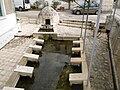
Wash house


literature
- Le Patrimoine des Communes de la Charente-Maritime. Flohic Editions, Volume 2, Paris 2002, ISBN 2-84234-129-5 , pp. 982-984.
Web links
Commons : La Chapelle-des-Pots - Collection of images, videos and audio files