
Saint-Bris-des-Bois
| Saint-Bris-des-Bois | ||
|---|---|---|
|
||
| region | Nouvelle-Aquitaine | |
| Department | Charente-Maritime | |
| Arrondissement | Saintes | |
| Canton | Chaniers | |
| Community association | Saintes | |
| Coordinates | 45 ° 46 ′ N , 0 ° 29 ′ W | |
| height | 31-95 m | |
| surface | 9.06 km 2 | |
| Residents | 389 (January 1, 2017) | |
| Population density | 43 inhabitants / km 2 | |
| Post Code | 17770 | |
| INSEE code | 17313 | |

Saint-Bris-des-Bois is a place and a western French community with 389 inhabitants (as of January 1 2017) in the Charente-Maritime in the region Nouvelle-Aquitaine . The municipality belongs to the arrondissement of Saintes and the canton of Chaniers (until 2015: canton of Burie ). The inhabitants are called Saint-Briciens .
location
Saint-Bris-des-Bois is located in the Saintonge about ten kilometers east-northeast of Saintes . Saint-Bris-des-Bois is surrounded by the neighboring communities of Brizambourg in the north, Villars-les-Bois in the northeast, Burie in the east, Saint-Sulpice-de-Cognac in the southeast and Saint-Césaire in the south and west.
The National Route 141 runs through the municipality .
Population development
| year | 1962 | 1968 | 1975 | 1982 | 1990 | 1999 | 2008 | 2017 |
| Residents | 237 | 260 | 267 | 285 | 359 | 391 | 418 | 389 |
| Sources: Cassini and INSEE | ||||||||
Attractions
- St-Brice Church , a historic monument since 1973
- Fontdouce Abbey , founded in 1111, Monument historique since 1986
See also: List of Monuments historiques in Saint-Bris-des-Bois
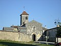
Saint-Brice church

Fontdouce Monastery


literature
- Le Patrimoine des Communes de la Charente-Maritime. Flohic Editions, Volume 1, Paris 2002, ISBN 2-84234-129-5 , pp. 177-179.