
Dompierre-sur-Charente
| Dompierre-sur-Charente | ||
|---|---|---|
|
||
| region | Nouvelle-Aquitaine | |
| Department | Charente-Maritime | |
| Arrondissement | Saintes | |
| Canton | Chaniers | |
| Community association | Saintes | |
| Coordinates | 45 ° 42 ′ N , 0 ° 29 ′ W | |
| height | 2-70 m | |
| surface | 8.29 km 2 | |
| Residents | 458 (January 1, 2017) | |
| Population density | 55 inhabitants / km 2 | |
| Post Code | 17610 | |
| INSEE code | 17141 | |
 Town hall (Mairie) of Dompierre-sur-Charente |
||

Dompierre-sur-Charente is a place and a western French community with 458 inhabitants (as of January 1 2017) in the Charente-Maritime in the region Nouvelle-Aquitaine . The municipality belongs to the arrondissement of Saintes and the canton of Chaniers (until 2015: canton of Burie ). The inhabitants are called Dompierrois .
location
Dompierre-sur-Charente is located in the Saintonge about eleven kilometers east-southeast of Saintes on the Charente , which borders the municipality in the south. Dompierre-sur-Charente is surrounded by the neighboring communities of Saint-Sauvant in the north, Chérac in the east and north-east, Rouffiac in the south, Saint-Sever-de-Saintonge in the west and south-west and Chaniers in the west and north-west.
The National Route 141 runs through the municipality .
Population development
| year | 1962 | 1968 | 1975 | 1982 | 1990 | 1999 | 2008 | 2014 |
| Residents | 351 | 381 | 374 | 359 | 398 | 414 | 460 | 458 |
| Sources: Cassini and INSEE | ||||||||
Attractions
- Saint Blaise Church
- old church of Orlac
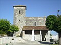
Saint Blaise Church
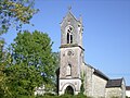
Orlac Old Church

.jpg)
literature
- Le Patrimoine des Communes de la Charente-Maritime. Flohic Editions, Volume 1, Paris 2002, ISBN 2-84234-129-5 , pp. 171-173.