
Pisany
| Pisany | ||
|---|---|---|
|
||
| region | Nouvelle-Aquitaine | |
| Department | Charente-Maritime | |
| Arrondissement | Saintes | |
| Canton | Thénac | |
| Community association | Saintes | |
| Coordinates | 45 ° 45 ′ N , 0 ° 49 ′ W | |
| height | 23-44 m | |
| surface | 6.59 km 2 | |
| Residents | 738 (January 1, 2017) | |
| Population density | 112 inhabitants / km 2 | |
| Post Code | 17600 | |
| INSEE code | 17278 | |

Pisany is a western French community with 738 inhabitants (as of January 1 2017) in the Charente-Maritime in the region Nouvelle-Aquitaine . The municipality belongs to the Arrondissement of Saintes and the Canton of Thénac (until 2015: Canton Saujon ). The inhabitants are called Pisanéens .
location
Pisany is located in the old cultural landscape of the Saintonge about ten kilometers west-southwest of Saintes . Pisany is surrounded by the neighboring communities of Corme-Royal in the north, Luchat in the east, Thézac in the south and Saint-Romain-de-Benet in the west.
Route nationale 150 runs through the municipality .
Population development
| year | 1962 | 1968 | 1975 | 1982 | 1990 | 1999 | 2006 | 2013 |
| Residents | 320 | 401 | 397 | 395 | 386 | 416 | 445 | 738 |
| Sources: Cassini and INSEE | ||||||||
Attractions
- Saint-Léonard chapel
- Market hall , built in the 17th century ( Monument historique )
- Pisany Castle with park, originally a castle from the 12th century, last rebuilt in the 17th century
See also: List of the Monuments historiques in Pisany

Pisany Castle with a park
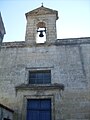
Saint-Léonard chapel

Market hall


literature
- Le Patrimoine des Communes de la Charente-Maritime. Flohic Editions, Volume 2, Paris 2002, ISBN 2-84234-129-5 , pp. 1054-1055.
Web links
Commons : Pisany - collection of pictures, videos and audio files