
Chursdorf (Seelingstädt)
|
Chursdorf
Community Seelingstädt
Coordinates: 50 ° 46 ′ 41 ″ N , 12 ° 15 ′ 42 ″ E
|
||
|---|---|---|
| Height : | 338 m above sea level NN | |
| Residents : | 350 | |
| Incorporation : | April 1, 1939 | |
| Postal code : | 07580 | |
| Area code : | 036608 | |
Location of Chursdorf in Thuringia |
||


Chursdorf is a district of Seelingstädt in the Greiz district in Thuringia with 350 inhabitants.
location
Chursdorf is located in the east of the district of Greiz, east of Seelingstädt on federal highway 175 in an arable area that is bordered by a forest to the south.
history
In 1378 Chursdorf was first mentioned in a document.
Monks of the Mildenfurth monastery prepared the settlement of the area. That is why it was possible to build the Christ Church as early as 1430 with the rights granted . The legal affiliation often changed, even the city of Werdau at times exercised these rights. The fron farmers were also redeemed early. There were the necessary craftsmen in the village to support the farm work. The railway opened up the place in 1876 with the Werdau – Weida line . The stop located in the village was renamed to Seelingstädt (near Werdau) Hp shortly after it was incorporated into Seelingstädt on April 1, 1939 . On May 24, 1998, the breakpoint was abandoned and the line shut down a year later.

Seelingstädt stop in Chursdorf (2016)
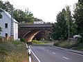
Chursdorf, railway viaduct (2016)
.jpg)

Web links
Individual evidence
- ^ Wolfgang Kahl : First mention of Thuringian towns and villages. A manual. Verlag Rockstuhl, Bad Langensalza 2010, ISBN 978-3-86777-202-0 , p. 48.
- ↑ www.sachsenschiene.net