Claramühle
|
Claramühle
Alfeld municipality
Coordinates: 49 ° 27 ′ 13 ″ N , 11 ° 33 ′ 40 ″ E
|
|
|---|---|
| Height : | 414 m above sea level NN |
| Residents : | 2 (Sep 30, 2017) |
| Postal code : | 91236 |
| Area code : | 09157 |
|
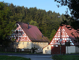
The Claramühle
|
|
Claramühle is located in the central Franconian district of Nürnberger Land near the border with the Upper Palatinate to the east . The homestead belongs to the municipality of Alfeld and forms its northernmost district.
location
The wasteland is at the point where the Albach valley, which had previously run in a north-easterly direction, takes a sharp U-turn to the north-west. The Mühlbach, a branch of the Happurger Bach, flows past. About a hundred meters south is the Regelsmühle , also part of the municipality of Alfeld.
history
A mill at the place where today's Claramühle is located is documented for the first time in 1275 . The two-story main building of the homestead was probably not built until the 18th century.
literature
- Fränkischer Albverein (Ed.): Driving and hiking 2 , second revised edition. Verlag Nürnberger Presse 1992, ISBN 3-920701-91-7
- Nuremberg country . Karl Pfeiffer's Buchdruckerei und Verlag, Hersbruck 1993, ISBN 3-9800386-5-3
Individual evidence
- ↑ Alfeld municipality, population figures (as of September 30 , 2017) (accessed on November 6, 2017)
- ↑ Location of the district in the Bavaria Atlas (accessed on November 6, 2017).
Web links
Commons : Claramühle (Alfeld) - Collection of images, videos and audio files
- Claramühle in the location database of the Bayerische Landesbibliothek Online . Bavarian State Library

