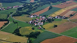
Seiboldstetten
|
Seiboldstetten
Alfeld municipality
Coordinates: 49 ° 26 ′ 23 " N , 11 ° 30 ′ 41" E
|
|
|---|---|
| Height : | 542 m above sea level NHN |
| Residents : | 54 (Sep 30, 2017) |
| Postal code : | 91238 |
| Area code : | 09157 |
|
The Alfeld district of Seiboldstetten
|
|
Seiboldstetten is a district of the municipality of Alfeld in Middle Franconia .
geography
The village is located about two and a half kilometers northwest of Alfeld and just under three kilometers north-northeast of the federal motorway 6 ( Nuremberg - Prague ).
history
As a result of the administrative reforms carried out in the Kingdom of Bavaria at the beginning of the 19th century , the place became a part of the independent rural community of Pollanden with the second municipal edict , which also included the church village Waller , the villages Gotzenberg and Lieritzhofen , and the hamlet Wettersberg . The hamlet of Wörleinshof and the wasteland of Röthenfeld were added later , and both places were only created at a later date.
Together with almost the entire municipality of Pollanden, Seiboldstetten was incorporated into the municipality of Alfeld in 1971 as part of the municipal territorial reform carried out in Bavaria in the 1970s . Only Gotzenberg was an exception, this village was first re-incorporated into the municipality of Thalheim in 1969 and then incorporated into Happurg together with it in 1972 . In 2017 Seiboldstetten had 54 inhabitants.
literature
- Eckhardt Pfeiffer (Ed.): Nürnberger Land . 3. Edition. Karl Pfeiffer's Buchdruckerei und Verlag, Hersbruck 1993, ISBN 3-9800386-5-3 .
Web links
- Seiboldstetten on a historical map (accessed October 10, 2017)
Individual evidence
- ↑ Alfeld municipality, population figures (as of September 30, 2017) (accessed on November 13, 2017)
- ^ Seiboldstetten in the local database of the Bayerische Landesbibliothek Online . Bayerische Staatsbibliothek (accessed on November 15, 2017)
- ↑ Location of the district in the Bavaria Atlas (accessed on November 13, 2017).
- ↑ Political composition of the rural community of Pollanden (accessed October 10, 2017)
- ↑ Historical municipality directory for the Federal Republic of Germany (1970-1982) . Page 715


