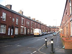
Coldhurst
| Coldhurst | ||
|---|---|---|
| Horsedge Street in Coldhurst | ||
| Coordinates | 53 ° 33 ′ N , 2 ° 7 ′ W | |
| OS National Grid | SD921058 | |
|
|
||
| Residents | 11,935 ( 2001 Census ) | |
| administration | ||
| Post town | OLDHAM | |
| ZIP code section | OL1 | |
| prefix | 0161 | |
| Part of the country | England | |
| region | North West England | |
| Metropolitan county | Greater Manchester | |
| Metropolitan Borough | Oldham | |
| British Parliament | Oldham West and Royton | |
Coldhurst (more rarely Cold Hurst ) is an area of Oldham and an electoral district of the Metropolitan Borough of Oldham in Greater Manchester , England. At the time of the United Kingdom Census 2001 , Coldhurst had 11,935 residents. The electoral district covers most of Oldham city center, although the name Coldhurst is conventionally used for the area north of the center.
Traditionally , Coldhurst is part of Lancashire and part of the old parish of Prestwich-cum-Oldham , within the Hundred of Salford, Salfordshire.
An old manor house that belonged to Abram Crompton gave Crompton Street its name.
It is said that Coldhurst was the site of an armed conflict during the English Civil War , in which the Round Heads were defeated.
As a result of the Industrial Revolution , Coldhurst developed industry and commerce, including coal mining , cotton mills, and hat making.
Coldhurst is now home to immigrants and their descendants from South Asia (especially from Bangladesh ). 37% of the population are of non-European origin and most whites live in “desolate social housing”. In 2001 Coldhurst was among the 5% of the most deprived constituencies in the United Kingdom.
supporting documents
Individual evidence
- ↑ a b United Kingdom Census 2001: Coldhurst (Ward) . neighborhood.statistics.gov.uk. Retrieved April 7, 2007.
- ^ A b Byron Criddle, Robert Waller: Almanac of British Politics . Routledge, Great Britain 2002, ISBN 0-415-26833-8 , p. 602.
- ^ A b c British History Online: 'Cold-Ashby - Coley' A Topographical Dictionary of England . Victoria County History. 1848. Retrieved April 7, 2007.
- ^ David Ritchie: The Ritchie Report . Oldham Independent Review. December 11, 2001. Archived from the original on February 4, 2012. Retrieved on April 7, 2007.
bibliography
- John Brownbill, William Farrer: A History of the County of Lancaster: Volume 5 . Victoria County History, 1911, ISBN 978-0-7129-1055-2 .
- Byron Criddle, Robert Waller: Almanac of British Politics . Routledge, Great Britain 2002, ISBN 0-415-26833-8 .

