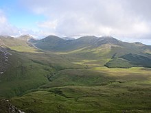
Connemara National Park
| Connemara National Park | ||
|---|---|---|
| View to Diamond Hill | ||
|
|
||
| Location: | Galway , Ireland | |
| Specialty: | Extensive moor and heathland | |
| Next city: | Clifden | |
| Surface: | 29.57 km² | |
| Founding: | 1980 | |
| Address: | Connemara National Park, Letterfrack, Co Galway | |
The Connemara National Park (English Connemara National Park ; Irish Páirc Naisiúnta Chonamara ) is one of the six Irish national parks . It is located in Connemara in the west of Ireland , in County Galway northwest of the Twelve Bens (also called twelve pins), a mountain range with twelve peaks.
history
The national park was established in 1980 and opened to the public. Much of the park's area used to be part of the Kylemore Abbey farm area . Relics of early human settlement such as 4,000-year-old megalithic structures and menhirs can be found in the area .
Flora, fauna and geology
The park has taken on the task of preserving nature and informing tourists and locals about the geological composition, flora and fauna of the region.
Numerous species of birds have been observed in the park, including skylarks, chaffinches, hawks and cormorants. Birds such as red thrush and field thrushes come to Connemara in winter from other regions of Ireland or from north-eastern Europe . The wild Connemara ponies live in the park . Rabbits , red foxes and pine marten are also represented. Red deer that used to live here have been exterminated and reintroduction has begun.
Bog and heathland landscapes shape the vegetation in the national park. The blue whistle grass and the wild purple rhododendron are particularly common in the national park , but there are also many other bog plants. A special feature of Connemara's vegetation is the occurrence of species from colder regions of Europe and the Arctic, for example rose arum or mountain sorrel , and at the same time the occurrence of species that are normally native to the Iberian peninsula, such as the butterwort Pinguicula lusitanica or the Irish bell heather Daboecia cantabrica . Larger trees have largely been cut down in the past centuries, with pines , spruces , oaks and alders being partially reforested.
The landscape was formed in the last ice age about 10,000 years ago. At that time, sand and gravel were deposited and many boulders were brought into the region by the ice masses. The peaks of the Twelve Bins are made of quartzite while the slopes are made of slate and gray marble .
Visitor center and national park administration
The national park belongs to the state. The National Parks Administration is part of the National Parks and Wildlife Service, an agency subordinate to the Irish Department for the Environment and Local Government.
The park entrance and visitor center is in Letterfrack on the N 59 Galway - Clifden - Westport . The national park administration and the visitor center are housed in the farm buildings of the former Letterfrack Industrial School. The visitor center has information material about flora, fauna, geology and excursions, and an exhibition clearly explains the formation of the moor and the use of the peat. Lectures and guided tours are offered regularly. Visitors can fortify themselves in a cafeteria . Furthermore there is a playground for children.
Various hiking trails lead through the park, the longest starting at the visitor center and leading to the summit of Diamond Hill, which is over 400 meters high .
See also
Web links
- Official site of the Connemara National Park (English)
- World Database on Protected Areas - Connemara National Park (English)
- Information brochure about the park (German, pdf)


