Corcovado (Chile)
| Corcovado | ||
|---|---|---|
|
View from Quellón to the volcano |
||
| height | 2300 m | |
| location | Chile | |
| Mountains | To the | |
| Coordinates | 43 ° 11 ′ 0 ″ S , 72 ° 48 ′ 0 ″ W | |
|
|
||
| Type | Stratovolcano | |
| Last eruption | 1835 | |
| First ascent | January 12, 1945 by Gerhard Kress, Alfredo Gash and Hans Engels | |
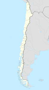
The Corcovado is a 2300 meter high volcano in the Andes Patagonia in southwest Chile . It is located opposite the island of Chiloé on the Gulf of Corcovado named after him . Nearby is the small town of Chaitén . The mountain lies in the volcanically very active zone of the South American Cordilleras . Its last major eruption occurred in 1835 .
The first ascent was made on January 12, 1945 by Gerhard Kress, Alfredo Gash and Hans Engels. The next documented ascent dates back to 1993 and was carried out by the American Douglas Tompkins and the Chilean Carlos Alvarado.
Individual evidence
- ↑ www.tecpetrol.com: Volcanes Australes ( Memento of the original from April 6, 2015 in the Internet Archive ) Info: The archive link was inserted automatically and has not yet been checked. Please check the original and archive link according to the instructions and then remove this notice. (Spanish)
- ↑ www.planetmountain.com: Volcán Corcovado in Patagonia (English)
Web links
Commons : Corcovado (Chile) - Collection of images, videos and audio files
- Corcovado (Chile) in the Global Volcanism Program of the Smithsonian Institution (English)

