
Corn da Mürasciola
| Corn da Mürasciola | ||
|---|---|---|
 Corn da Mürasciola, taken from Val da Camp |
||
| height | 2818 m above sea level M. | |
| location | Canton of Graubünden , Switzerland | |
| Mountains | Livigno Alps | |
| Dominance | 1.28 km → Corn da Camp | |
| Notch height | 137 m ↓ Fuorcla da Cardan | |
| Coordinates | 804 425 / 142 693 | |
|
||
| Normal way | Over the southeast slope | |
 View from the Bernina Pass |
||
 Steinmann on the Corn da Mürasciola |
||

The Corn da Mürasciola ( Italian , diminutive, derivation of mür , Latin murus for 'wall') is a mountain east of the Bernina Pass in the canton of Graubünden in Switzerland with a height of 2818 m above sea level. M.
Location and surroundings

The Corn da Mürasciola belongs to the Cima di Cardan group, a subgroup of the Livigno Alps . The summit is entirely within the municipality of Poschiavo . The Corn da Mürasciola is bordered in the northeast by the Val Mera, in the southeast by the Val Camp and in the west by the Val Laguné. The valleys all belong to the Poschiavo .
The neighboring peaks include Corn da Camp in the north, Scima da Saoseo in the southeast, Scima da Rügiul in the south and Piz Campasc in the west.
The farthest visible point ( 46 ° 43 '43.2 " N , 10 ° 59' 7" O ) is from Corn da Mürasciola to east direction, 590 m northwest of the Roteck in South Tyrol , and is 76.8 km away.
On the southwest flank is the I Lagh da Mürüsciola , a mountain lake at 2611 m .
The valley location is La Rösa . Frequent starting point of the Rifugio Saoseo ( 1986 m ).
Routes to the summit
Summer routes
The Val da Camp is closed to general traffic. Rifugio Saoseo and after camp, however, in summertime post bus -line of Sfazù at the Bernina Pass road . The starting points can be reached on foot in 1½ hours.
Over the southeast slope
- Starting point: Rifugio Saoseo ( 1986 m )
- Via: I Lagh da Mürüsciola , pre-summit in the west
- Difficulty: T3
- Time required: 2½ hours
Over the northwest ridge
- Starting point: Rifugio Saoseo ( 1986 m )
- Via: Val Mera, Forcula da Cardan
- Difficulty: T4 +
- Time required: 3 hours
Winter routes
Usually only the pre-summit is climbed. The west ridge to the main summit is often too tricky in winter.
Over the southeast slope
- Starting point: Rifugio Saoseo ( 1986 m )
- Via: I Lagh da Mürüsciola
- Exposures: S
- Difficulty: WS
- Time required: 2½ hours
panorama

gallery
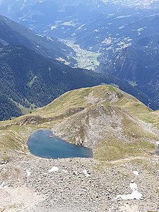
View down to I Lagh da Mürüsciola and the Puschlav in the background.
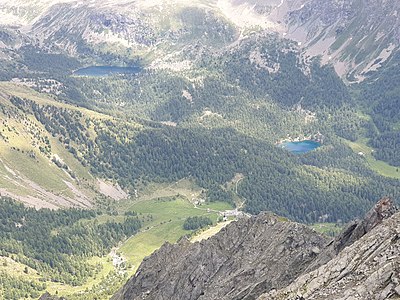
View to Lagh da Saoseo (below) and Lagh da Val Viola (above).

The Corn da Mürasciola, taken from the Lagh da Saoseo .


literature
- National map of Switzerland, sheet 1278 La Rösa, 1: 25,000, Federal Office of Topography, 2017 edition
- Sabine Joss, Fredy Joss: Alpine hiking / Engadin, summit destinations between Samnaun and Bergell . Verlag des SAC, 2010, ISBN 978-3-85902-327-7 , p. 144-147 .
Web links
- Calculated 360 ° panorama from Corn da Mürasciola
- Tour reports on www.hikr.org
Individual evidence
- ↑ Andrea Schorta: How the mountain got its name . Small Rhaetian name book with two and a half thousand geographical names of Graubünden. Terra Grischuna Verlag, Chur and Bottmingen / Basel 1988, ISBN 3-7298-1047-2 , p. 107 .
- ↑ Calculated 360 ° panorama ( U. Deuschle ; information ) from Corn da Mürasciola