
Crevole (river)
| Crevole | ||
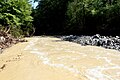
 The crevole at the Ponte Nero bridge |
||
| Data | ||
| location | Tuscany , Province of Siena , Italy | |
| River system | Ombrone | |
| Drain over | Ombrone → Tyrrhenian Sea | |
| River basin district | Appennino Settentrionale | |
| source | Northwest of Crevole (Murlo) 43 ° 11 ′ 27 ″ N , 11 ° 20 ′ 3 ″ E |
|
| muzzle | at La Befa (Murlo) in the Ombrone coordinates: 43 ° 6 ′ 43 " N , 11 ° 24 ′ 8" E 43 ° 6 ′ 43 " N , 11 ° 24 ′ 8" E |
|
| Mouth height | approx. 151 m slm
|
|
| length | 16 km | |
| Left tributaries | Fosso dello Scanno | |
| Communities | Murlo | |
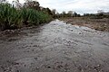
The Crevole is a 16 km long river ( Torrente ) in the Tuscany region of Italy, which flows from north to south in the province of Siena in the municipality of Murlo and flows into the Ombrone as a right tributary shortly after La Befa (district of Murlo) .
course
The river rises in the hills just northeast of the castle ruins Castello di Crevole in the northern municipality of Murlo and flows from here to the southeast. It passes the districts of Lupompesi (291 m) and Vescovado (294 m) located below in the valley to the south-west and then flows further south and west past the Castello di Murlo castle , which gives the municipality its name . From there it goes further south, where shortly before Miniera di Murlo the Fosso dello Scanno flows in from the left . After the former operating buildings of the Miniera di Murlo mines (198 m), the river reaches the ruins of the Ponte Nero bridge (184 m, a former bridge of the mine railway, which has been replaced by a metal footbridge). The Crevole then passes the ruins of the Ponte di Miro bridge and flows further south through the Crevole valley ( Valle del Crevole ) to La Befa (also a district of Murlo, 151 m). Here it flows into the Ombrone as a right tributary not far from the Murlo train station .
Attractions
-
Castello di Crevole , castle ruins just southwest of the source. 43 ° 11 ′ 3 ″ N, 11 ° 21 ′ 37 ″ E
- Pieve di Santa Cecilia , church of Crevole Castle that still exists today. Lies below the castle on the edge of the Borgo and was mentioned as early as 1189. 43 ° 11 ′ 2 ″ N, 11 ° 21 ′ 30 ″ E
- Ponte Nero , ruined bridge that has been replaced by a pedestrian bridge. The last pillar parts of the original bridge collapsed after a flood in 2008. Had a length of 38.50 m. 43 ° 8 ′ 18 ″ N, 11 ° 22 ′ 51 ″ E
- Ponte di Miro , ruined bridge of which only the foundations of the pillars remain. 43 ° 8 ′ 10 "N, 11 ° 22 ′ 57" E
photos
The Crevole at Crevole (Murlo)

Ponte Nero

The ruins of the Ponte di Miro bridge

Valley of the Crevole (Valle del Crevole)
The Crevole near La Befa just before the confluence with the Ombrone


literature
- Rolf Goetz: On the disused Murlo railway line. In: Tuscany South. Online version from google books , accessed April 2, 2017
Web links
Individual evidence
- ↑ a b c d e Official website of the ISTAT ( Istituto Nazionale di Statistica ) on the places and districts 2001 in the province of Siena, accessed on April 2, 2017 (Italian)
- ↑ Sistema Informativo Ambientale della Regione Toscana (SIRA)
- ↑ a b Luciano Scali: I segreti inediti del Ponte Nero. In: MurloCultura 2013 - No. 1 , accessed on April 3, 2017 (Italian)
- ^ A b Rolf Goetz: On the disused railway line from Murlo.
- ↑ Pieve di Santa Cecilia a Crevole on the website of I luoghi della Fede of the Regione Toscana, accessed on April 2, 2017 (Italian)