Crooked Island
| Crooked Island | ||
|---|---|---|
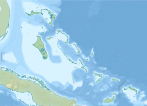
| Topographic map with Crooked Island (northwest) and Acklins (east) | ||
| Waters | Atlantic | |
| Geographical location | 22 ° 45 ′ N , 74 ° 14 ′ W | |
|
|
||
| length | 37 km | |
| width | 14 km | |
| surface | 148 km² | |
| Highest elevation | Bullets Hill 35 m |
|
| Residents | 323 (2010) 2.2 inhabitants / km² |
|
| main place | Colonel Hill | |
| Map of Crooked Island | ||
Crooked Island is an island and a district of the Bahamas .
It is one of a group of islands in a shallow lagoon called Bight of Acklins , the largest of which is Crooked Island in the north and Acklins in the southeast. The smaller ones are Long Cay (formerly: Fortune Island ) in the northwest and Castle Island in the south.
The islands were settled by American loyalists during the American Revolution in the late 1780s, who established cotton plantations here with over 1,000 employed slaves. After the ban on slavery in the British Empire, the plantations became uneconomical, and the replacement, diving for sponges, is no longer economical either. In the meantime, the residents live from fishing and small farms.
The capital is Colonel Hill on Crooked Island. Albert Town , located on Long Cay and sparsely populated, was once a thriving small town. It also made a living from the sponge trade and salt industries and was also a port of transport for dock workers who looked for work on the passing ships.
The population at the 2010 census was 560 on Acklins and 323 on Crooked Island.
The Bahamas' first post office is believed to have opened in Pitt's Town on Crooked Island.


