Exuma (Bahamas)
| Exuma | ||
|---|---|---|
| Emerald Bay, Great Exuma Island | ||
| Waters | Atlantic Ocean | |
| archipelago | Bahamas | |
| Geographical location | 23 ° 43 ′ N , 76 ° 5 ′ W | |
|
|
||
| Number of islands | 365 | |
| Main island | Great Exuma | |
| Total land area | 250 km² | |
| Residents | 7314 (2010) | |
|
Exuma Cays in the northwest of the main island of Great Exuma |
||
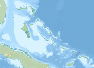
Exuma is the name of a district in the Bahamas that consists of over 360 islands. The archipelago is a popular destination for sailors and divers because of its reefs and caves. Many unnamed beaches and caves, as well as offshore reefs, are part of the protected Exuma National Land and Sea Park of the Bahamas National Trust .
The Exumas were first inhabited by the Lucayan Indians and other Arawaks who were enslaved in the 15th century. The islands were subsequently uninhabited until the 17th century, but were used by pirates as hiding places.
Great Exuma
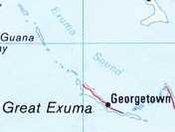
The largest island is Great Exuma with a length of 60 km and an area of 72 km² . There is also the largest city in the archipelago, George Town , with a population of 1436 (2010 census). The city, founded in 1793, bears its name in honor of the British King George III. The Tropic of Cancer runs through this city .
Exuma was settled around 1783 by American loyalists who fled the Revolutionary War . The cotton plantations also go back to these settlers . Lord John Rolle , one of the settlers, is an important figure in the island's history. On his death in 1835, he gave all of his Exuma land to his slaves; as a thank you, several localities were named after him (such as Rolleville and Rolletown ).
transport
The district has an airport in the city of George Town with Exuma International Airport , which offers flights to Nassau, Miami, Atlanta and Toronto. The village of Staniel Cay also has a small airfield.
Refugee drama in November 2013
When an overloaded sailing boat carrying refugees from Haiti capsized on November 25, 2013, at least ten people died off the coast of the southern village of Staniel Cay. The boat ran aground east of the village. The Royal Defense Forces of the Bahamas and the Coast Guard began the rescue operation immediately after the distress call was released and rescued more than 100 Haitians.
Web links
Individual evidence
- ↑ History of Exuma ( Memento of the original from April 19, 2006 in the Internet Archive ) Info: The archive link was automatically inserted and not yet checked. Please check the original and archive link according to the instructions and then remove this notice. on peaceandplenty.com
- ↑ Exuma Cays
- ↑ Discover
- ↑ on Exuma Bahamas ( page no longer available , search in web archives ) Info: The link was automatically marked as defective. Please check the link according to the instructions and then remove this notice.
- ↑ (GGT) Exuma International Airport - FlightStats , accessed November 26, 2013
- ↑ Airport information for MYES
- ↑ CBS News : At Least 30 Dead After Haitian Boat Capsizes Near Bahamas, November 26, 2013
- ↑ BBC News : Rescue operation as boat with Haitian migrant capsizes of November 26, 2013


