Grand Bahama
| Grand Bahama | ||
|---|---|---|
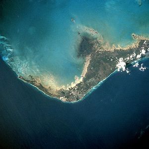
| NASA image of Grand Bahama | ||
| Waters | Atlantic | |
| Archipelago | Bahamas | |
| Geographical location | 26 ° 39 ′ N , 78 ° 19 ′ W | |
|
|
||
| length | 154 km | |
| width | 27 km | |
| surface | 1 373 km² | |
| Residents | 51,756 (2010) 38 inhabitants / km² |
|
| main place | Freeport | |
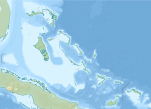
| Map of Grand Bahama | ||
Grand Bahama is one of the northernmost islands of the Bahamas and is located about 90 km off the coast of Florida , USA .
history
The first known inhabitants of the island were the Siboney Indians in the Stone Age , of whom there are only a few remains apart from a few artifacts such as shell ornaments and jewels. These people may have disappeared when Taíno - Arawaks from South America colonized most of the Caribbean islands in their canoes .
The Arawak communities in the great Bahamas, known as the Lucayans , subsequently became a well-organized society in both social and political terms. At the time of the arrival of the first Spaniards in 1492, the number of inhabitants is estimated at around 4,000. As a result, the aborigines were wiped out by diseases brought in from Europe, atrocities by Europeans and deportation into slavery (as miners on the Caribbean islands of Hispaniola and Cuba , as pearl divers on Trinidad ). The Lucayans disappeared so quickly that very little is known about the people. In the Lucayan National Park and Dead Man's Reef several artifacts have been found that indicate complex burial rituals.
The Spanish called the island Gran Bajamar , which means "great shallows". The numerous coral reefs were very dangerous and led to the withdrawal of the Spaniards (with the exception of occasional stops of passing ships to take supplies). They attracted pirates for this , who pushed ships onto the reefs and then plundered them. The Spaniards had very little interest in the island after the aboriginal exploitation, and so the island was taken over by the English in 1670 . Piracy remained a problem for half a century, but it was increasingly brought under control. Great Bahamas history was very quiet until the mid-19th century, with only 200 to 400 residents living in the capital, West End .
In 1834 the towns of Pinder's Point , Russell Town and Williams Town were founded by ex-slaves after the prohibition of slavery in England. The island was economically underdeveloped until the American Civil War. The smuggling of goods for the Confederation (especially arms, sugar and cotton) led to an economic boom. A second brief boom through smuggling took place during prohibition .
On September 2, 2019, the very slowly moving severe Hurricane Dorian first crossed the island of Great Abaco further east and then Grand Bahama.
Economic development
In the mid-20th century, Great Bahama had a population of around 500 and the island was one of the least economically developed in the Bahamas. With the establishment of the city of Freeport by the financier Wallace Groves from Virginia, the island came to a stable source of income in 1955. Groves saw the success of Cuba as a tourist destination and wanted to develop the Bahamas in a similar direction. The city grew rapidly when Groves built a port and in 1962 the tourist hub of Port Lucaya .
Freeport became the second largest city in the Bahamas (over 50,000 (2004)), and tourists are now the island's main source of income. There is also an oil storage facility owned by the Venezuelan government and a transport port operated by the Hong Kong-based CK Hutchison Holdings group .
Other cities and towns
West End , the capital of Grand Bahama until Freeport was founded, is the oldest and most westerly city on the island. McLeans Town is the easternmost settlement and can be reached by ferry in around 30 minutes from the northernmost settlement of Abaco .
Individual evidence
- ↑ 13,000 houses severely damaged or destroyed in Bahamas (English), The Guardian, September 2, 2019.


