Freeport (Bahamas)
| Freeport | ||
|---|---|---|
|
|
||
| Coordinates | 26 ° 32 ′ N , 78 ° 42 ′ W | |
| Basic data | ||
| Country | Bahamas | |
| Freeport | ||
| ISO 3166-2 | BS-FP | |
| Residents | 26,910 (2000) | |
| founding | 1955 | |
|
Lucayan Harbor Jon Worth in Freeport
|
||
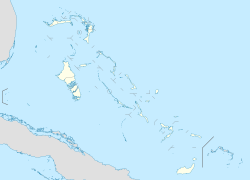
Freeport is a city and free trade zone on the island of Grand Bahama , which is about 160 km northeast of Fort Lauderdale ( Florida ). The population was 26,910 in 2000.
history
In 1955, Wallace Groves , a Virginia financier who first became interested in growing timber on the island, received over 200 km² of land from the Bahamas government. On this land he founded the city of Freeport , which soon became the second largest in the Bahamas (after Nassau ).
The city was badly affected by Hurricane Dorian in August 2019.
economy
The Grand Bahama Port Authority (GBPA) operates the free trade area under the Hawksbill Creek Agreement signed in August 1955 . The agreement states that there will be no duties to be paid until 2054.
After trading, tourism is Freeport's second source of income with around one million visitors a year. Much of the tourism industry is on the coast of the Lucaya district , which takes its name from the pre-Columbian Lucayan indigenous people.
traffic
The port can also be used by the largest ships and has a berth for cruise ships , a container port and a private marina including a maintenance dock.
The airport Freeport ( IATA airport code : FPO , ICAO code : MYGF ) handles almost 50,000 takeoffs and landings per year.
Born in Freeport
- Sebastian Bach (* 1968), formerly singer of the rock group Skid Row
- Quentin Hall (born 1977), basketball player
- Andre Deveaux (* 1984), ice hockey player in the NHL plays
- Buddy Hield (born 1992), basketball player

