Cwmyoy
| Cwmyoy | ||
|---|---|---|
|
|
||
| Coordinates | 51 ° 54 ′ N , 3 ° 1 ′ W | |
| Basic data | ||
| Country | United Kingdom | |
|
Part of the country |
Wales | |
| Unitary Authority | Monmouthshire | |
| ISO 3166-2 | GB-MON | |
|
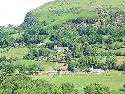
Cwmyoy, with Hatteral Hill in the background
|
||
Cwmyoy is a sprawling rural parish in Monmouthshire in the British part of Wales . The common Welsh name is Cwm Iau (for the parish) and Cwm-iau (for the parish). In the Gwentish dialect of the Welsh language, which was spoken there until the end of the 19th century, the name was pronounced as Cmw Iou (informal also -oi ; -au is widespread in South Wales). The current “English” name Cwmyoy goes back to the fact that the dialect in this area has strong influences from the English language . The name for the valley is believed to be derived from iau , the Welsh word for a yoke , because the hill that surrounds the valley is shaped like a yoke.
Cwmyoy is about nine kilometers north of Abergavenny and five kilometers south of Llanthony in the Vale of Ewyas in the Black Mountains . It is located in the Brecon Beacons National Park on an elevated position below the long ridge of Hatterrall Hill , which is the border with England and the Offa's Dyke Path .
The community
The municipality extends over a length of about ten and a width of a good one kilometer and includes Llanthony in addition to Cwmyoy . 1983 Ffwddog ( Engl. Fothock), an exclave of Herefordshire in the neighboring valley of Grwyne Fawr , Cwmyoy was struck.
Facilities and tourism
The area around Cwmyoy is popular with hikers, whether on foot or by pony. To reach Llanthony Priory , Capel-y-ffin and the Gospel Pass, one must take the path through the valley of Cwmyoy.
Cwmyoy also has a small town hall that is also used for charitable events.
St Martin's Church
The most famous sight of Cwmyoy is St Martin's Church , which as "the most crooked church in Great Britain" ( Engl. For "the schiefste Church in the UK is considered").
St Martin's Church is a red sandstone parish church located on the south side of Hatteral Hill that has been severely displaced by the movement of the unstable subsurface.
The choir of the church is a remarkable example of a "weeping chancel" (English for weeping choir ), the nave represents the body of Jesus Christ and the displaced choir the head, who leaned to one side after his death. In Cwmyoy, however, there is not just one bend in the axis between the nave and the choir, the unstable subsurface causes the entire part of the building to lean to one side.
Individual evidence
- ^ HW Owen, R. Morgan: Dictionary of the Place-names of Wales. Gomer Press, Llandyssul, 2007
- ↑ Cwmyoy. In: Kelly's Directory of Monmouthshire. 1901, accessed September 27, 2019 .
- ↑ Cwmyoy Memorial Hall. In: Open Charities. September 1, 2019, accessed on September 27, 2019 .
- ^ Places of Worship: St Martin, Cwmyoy. In: Crucorney Community Portal. June 19, 2017, accessed September 2, 2019 .
Web links
- Simon Jenkins: Cwmyoy. In: theguardian.com . December 22, 2006 (English).


