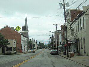
Cynthiana (Kentucky)
|
|
This article was on the basis of substantive defects quality assurance side of the project USA entered. Help bring the quality of this article to an acceptable level and take part in the discussion ! A closer description on the resolving issues is missing. |
| Cynthiana | |
|---|---|
 Downtown Cynthiana |
|
| Location in Kentucky | |
| Basic data | |
| Foundation : | 1793 |
| State : | United States |
| State : | Kentucky |
| County : | Harrison County |
| Coordinates : | 38 ° 23 ′ N , 84 ° 18 ′ W |
| Time zone : | Eastern ( UTC − 5 / −4 ) |
| Residents : | 6,258 (as of: 2000) |
| Population density : | 719.3 inhabitants per km 2 |
| Area : | 8.7 km 2 (approx. 3 mi 2 ) |
| Height : | 224 m |
| Postal code : | 41031 |
| Area code : | +1 859 |
| FIPS : | 21-19432 |
| GNIS ID : | 0490519 |
| Website : | www.cynthianaky.com |
| Mayor : | James D. Smith |
Cynthiana is a small town in Harrison County in the US state of Kentucky .
According to the United States Census 2000 , the city had a population of 6,258 people. The city is also the county seat of the county.
Cynthiana is located at 38 ° 23 '18 "North, 84 ° 17' 49" West (38.388292, −84.296841) and extends over 8.7 km² .
In the winter of 1963 the lowest meteorological extreme values of the state were measured here at -36.7 ° C.
sons and daughters of the town
- Benjamin B. Hinkson (≈1799–1877), lawyer and politician
- Nicholas D. Coleman (1800–1874), politician
- Orville Hickman Browning (1806–1881), US Secretary of the Interior
- Caleb Walton West (1844–1909), politician
- J. Stanley Webster (1877–1962), lawyer and politician
- William McKinney (1895-1969), jazz drummer
- Joe Russell Whitaker (1900-2000), geographer
- Lawrence Pressman (born 1939), actor
Web links
Commons : Cynthiana (Kentucky) - Collection of pictures, videos, and audio files
