Dürrbach (Orla)
| Dürrbach | ||
|
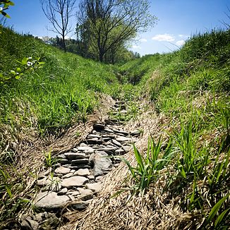
Dry section of the Dürrbach on the Drommberg east of Kolba |
||
| Data | ||
| location | Germany , Thuringia | |
| River system | Elbe | |
| Drain over | Orla → Saale → Elbe → North Sea | |
| Headwaters | east of the "Dürrbachsmühle" near Weira 50 ° 41 ′ 16 ″ N , 11 ° 43 ′ 36 ″ E |
|
| Source height | approx. 485 m above sea level NN | |
| muzzle | near Kolba (municipality of Oppurg ) from the left into the Orla coordinates: 50 ° 43 '14 " N , 11 ° 40' 38" E 50 ° 43 '14 " N , 11 ° 40' 38" E |
|
| Mouth height | approx. 230 m above sea level NN | |
| Height difference | approx. 255 m | |
| Bottom slope | approx. 51 ‰ | |
| length | 5 km | |
The Dürrbach is a 5 km long brook in East Thuringia that flows into the Orla from the left and south near Kolba in the municipality of Oppurg in the Saale-Orla district .
course
It rises east of the "Dürrbachsmühle" in a field at the "Weiraer Wald". The brook flows from the south towards the Orla , repeatedly dammed by ponds , but does not reach the Orla above ground in the dry summer months - the water seeps through calcareous rock layers, so-called fruit fissures, and thus flows underground to the Orla.
Web links
Commons : Dürrbach - Collection of images, videos and audio files
