
Dalkarlsberg
| Dalkarlsberg | ||||||
|
||||||
| State : | Sweden | |||||
| Province (län): | Örebro län | |||||
| Historical Province (landskap): | Vastmanland | |||||
| Municipality : | Nora | |||||
| Coordinates : | 59 ° 26 ' N , 14 ° 52' E | |||||
| SCB code : | S6029 | |||||
| Status: | Småort | |||||
| Residents : | 93 (December 31, 2015) | |||||
| Area : | 0.57 km² | |||||
| Population density : | 163 inhabitants / km² | |||||

Dalkarlsberg is a place ( småort ) in the Swedish province of Örebro län and the historical province (landskap) Västmanland .
The place is located about fifteen kilometers southwest of the main town of Nora in the municipality of the same name Nora Nora. The Striberg – Degerfors railway of the former Vikern – Möckelns Järnväg ran through the former mining settlement (Eisenerz) . Today it is shut down and dismantled. At the site of leading Swedish county road 243 (provincial road) over.
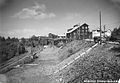
Pit (1939)

Individual evidence
- ↑ a b Statistiska centralbyrån : Småorter 2015, byggnader, areal, överlapp tatorter, coordinater (Excel file)
Places in the municipality of Nora