Değirmendere
|
Değirmendere ancient name: Piksidis |
||
|
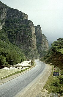
Değirmendere near Maçka (photo from 1990) |
||
| Data | ||
| location | Trabzon ( Turkey ) | |
| River system | Değirmendere | |
| Headwaters |
Zigana Mountains 40 ° 39 ′ 55 ″ N , 39 ° 23 ′ 44 ″ E |
|
| Source height | approx. 2000 m | |
| muzzle |
Black Sea Coordinates: 41 ° 0 ′ 10 ″ N , 39 ° 45 ′ 25 ″ E 41 ° 0 ′ 10 ″ N , 39 ° 45 ′ 25 ″ E |
|
| Mouth height | 0 m | |
| Height difference | approx. 2000 m | |
| Bottom slope | approx. 33 ‰ | |
| length | approx. 60 km | |
| Right tributaries | Altındere , Galyan Deresi | |
| Big cities | Trabzon | |
| Small towns | Maçka | |
| Communities | Anayurt | |
The Değirmendere ( Turkish for "Mühlbach") is a river to the Black Sea in the northern Turkish province of Trabzon . The river was called Piksidis in ancient times .
The Değirmendere has its source at the Zigana Pass on the provincial border with Gümüşhane . The European route 97 / trunk road D885 follows the course of the river to Trabzon on the Black Sea. The Değirmendere flows through the district of Maçka in a predominantly north-northeast direction. It passes the village of Anayurt and the district town of Maçka. Larger tributaries are Altındere and Galyan Deresi , both from the right. Finally it flows into the Black Sea on the eastern edge of the provincial capital Trabzon. The Değirmendere has a length of about 60 km.
