Deep Creek (Maribyrnong River)
| Deep Creek | ||
|
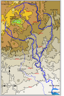
Relief map of the Maribyrnong River and its source streams |
||
| Data | ||
| location | Victoria , Australia | |
| River system | Yarra River | |
| Drain over | Maribyrnong River → Yarra River → Port Phillip Bay → Bass Strait | |
| source | Mount Macedon and Cobaw Range in the Great Dividing Range 37 ° 30 ′ 13 ″ S , 144 ° 53 ′ 1 ″ E |
|
| Source height | 517 m | |
| muzzle |
Maribyrnong River Coordinates: 37 ° 40 ′ 10 ″ S , 144 ° 48 ′ 16 ″ E 37 ° 40 ′ 10 ″ S , 144 ° 48 ′ 16 ″ E |
|
| Mouth height | 41.6 m | |
| Height difference | 475.4 m | |
| Bottom slope | 3.7 ‰ | |
| length | 128 km | |
| Left tributaries | Boyd Creek, Dry Creek, Garden Hut Creek, Long Gully Creek | |
| Right tributaries | Emu Creek, Konagaderra Creek, Monument Creek, Five Mile Creek | |
| Small towns | Lancefield , Bulla | |
| Communities | Darraweit Guim, Kongaderra | |
|
Bulla Bridge, built in 1869 |
||
The Deep Creek is a creek in the south of the Australian state of Victoria and a headwaters of the Maribyrnong River .
course
It rises on the northeast slopes of Mount Macedon north of Melbourne and also receives tributaries from the southern slopes of the Cobaw Range . Both mountains belong to the Great Dividing Range .
The Deep Creek flows south and joins the Jackson Creek to the Maribyrnong River. In its upper reaches it flows east into the broad, flat valley of Lancefield , and then continues its course south through the deeper, narrower valley from which its name is derived. Then the brook flows a few kilometers to the east, only to take a southerly direction at Darraweit Guim . At Bulla it then unites with Jacksons Creek. The deep and relatively narrow valley that the creek has dug into the basalt plateau is particularly beautiful in places like Darraweit Guim , Konagaderra and Bulla .
The stream is not regulated, so its water level varies greatly with the seasons. In recent years, Deep Creek only has continuous water in the wet season, only in a few places there is water all year round. These pools are very popular for swimming in the area.
Tributaries
The tributaries of Deep Creek are ordered upstream
- Emu Creek
- Konagaderra Creek
- Boyd Creek
- Five Mile Creek
- Long Gully Creek
- Dry Creek
- Monument Creek
- Garden Hut Creek
Stream crossings
Bridges and other stream crossings (ordered upstream, selection) are
- Bulla Bridge; currently a stone bridge with four arches, built in 1869, replaced an earlier wooden bridge
- Wildwood Road
- Konagaderra Road
- McCabes Bridge (Stockdale Road)
- Darraweit Valley Road
- Chintin Road
- Gallagher's Ford (Joyces Road)
- Dalys Bridge (Woodend - Wallan Road)
- Sheehans Crossing bridge (Sheehans Road)
- Forbes Bridge (Forbes Road)
- Doggetts Bridge (Lancefield - Kilmore Road)
- Musteys Bridge (Lancefield - Tooborac Road)
- Linehans Bridge (Baynton Road) (was replaced by a low dam in the 1990s; the old bridge was closed and demolished)
- Twin Bridges (Kyneton - Lancefield Road)
- White Bridge (Whitebridge Road)
Etymology and changing names
The creek was originally considered part of the Maribyrnong River and was therefore also called the 'Saltwater River', 'Upper Maribyrnong River', 'Maribyrnong Creek', 'Maribyrnong River East Branch' or 'Maribyrnong River Left Branch'. Another name is 'Darraweit Guim', the name of a small town on the brook. The current name 'Deep Creek' could refer to the deep valley that the watercourse has carved into the plateau north of Melbourne, or to the deep pools in the creek bed.
See also
Web links
Individual evidence
- ↑ a b c Map of Deep Creek, VIC . Bonzle.com
- ↑ Deep Creek, Lancefield . Fishing Victoria Project ( Memento of the original from February 17, 2011 in the Internet Archive ) Info: The archive link was automatically inserted and not yet checked. Please check the original and archive link according to the instructions and then remove this notice.
- ↑ a b Maribyrnong River Basin 30 . Department of Primary Industries. Government of Victoria
- ^ Maribyrnong River Visitors Guide . Parks Victoria ( Memento of the original from March 16, 2011 in the Internet Archive ) Info: The archive link has been inserted automatically and has not yet been checked. Please check the original and archive link according to the instructions and then remove this notice.
- ^ JS Duncan (ed.): Atlas of Victoria . Victorian Government Printing Office. Melbourne 1982, p. 207.
- ^ Victorian Municipal Directory . Arnall & Jackson. Brunswick VIC 1956, p. 791.
- ^ Ian William Symonds: Bulla Bulla, an Illustrated History of the Shire of Bulla . Spectrum, Melbourne 1985, ISBN 0-86786-081-2 .

