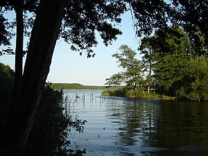
Dehmsee
| Dehmsee | ||
|---|---|---|

|
||
| Dehmsee in summer 2010 | ||
| GKZ | DE: 5827749 | |
| Geographical location | Fürstenwalder Spreetalniederung on the southern edge of the Lebuser Platte east of Fürstenwalde / Spree , Oder-Spree district , Brandenburg, Germany | |
| Tributaries | Demnitz mill flow | |
| Drain | Fürstenwalder Spree (in the west) | |
| Islands | Fischwerder | |
| Places on the shore | Berkenbrücker settlement "Am Dehmsee" | |
| Location close to the shore | Fürstenwalde / Spree (8.5 km from the town hall) | |
| Data | ||
| Coordinates | 52 ° 20 '21 " N , 14 ° 10' 30" E | |
|
|
||
| Altitude above sea level | 38.3 m | |
| surface | 1.11 km² | |
| length | 1,364 km | |
| width | 1.09 km | |
| volume | 2,000,000 m³ | |
| Maximum depth | 3 | |
| Middle deep | 1.8 m | |
| Catchment area | 74 km² | |
The Dehmsee is a lake near Fürstenwalde / Spree in Brandenburg .
Natural location
The Dehmsee is located in the Fürstenwalder Spree valley. Its only tributary is the Demnitzer Mühlenfließ , which drains the northern Lebuser Platte . The runoff takes place via the nearby Spree, which flowed through the lake before it was channeled . The island of Fischwerder lies in the water. The A12 runs directly on its north bank .
The Dehmsee is a lime-rich, unstratified lake with a relatively large catchment area.
etymology
The name of the lake is probably derived from the pre-Slavic-Germanic * Dem- ("dark") after the color of the water. The forms “Deme” (1373), “der Dehmen” (1606), “der Dehm” (1751), “der Dehm See” (1775) are documented.
Trophic characteristics
The profile according to the EU Water Framework Directive certifies the Dehmsee 2017 an ecological status of 5 (= "bad status": the values for the biological quality components show significant changes and large parts of the biocenoses of the reference status are missing) on a five-point scale. The quality component phytoplankton also has a value of 5. The LAWA trophy index in 2014 was 4.1. This made the lake polytrophic .
history
Findings of settlements on the north bank of the Dehmsee and on the island of Fischwerder indicate a settlement in the Mesolithic around 8000 to 3000 BC. Chr. Prehistoric and late Slavic pottery fragments were found on Fischwerder . Remnants of bridge posts that lead to a Slavic rampart on the west bank of the lake indicate an earlier Slavic island castle .
In 1932/33 the writer Hans Fallada lived in the Berkenbrücker district of Roter Krug within sight of the lake. Here he wrote his novel Who once eats out of a tin bowl .
When the autobahn was built in the 1930s, the Dehmsee was cut with the help of a dam. The popular excursion restaurant "Roter Krug" received a 3rd class exit. The Berkenbrück exit was closed after the Fürstenwalde-Ost exit was opened and closed to traffic. The bridge over the Dehmsee was blown up by the Wehrmacht on April 23, 1945 .
Until 1989, the Ministry for State Security on Dehmsee maintained the " Feliks Dzierżyński " holiday camp for the children of its employees. Today the site lies fallow.
Individual evidence
- ↑ a b Dehmsee: History at the Wasserstraßen- und Schifffahrtsamt Berlin , accessed on March 31, 2019.
- ↑ a b c d e f g h i Profile Lakes EC Water Framework Directive: Dehmsee . (PDF; 391 kB), State Office for the Environment Brandenburg , Section W14, as of October 10, 2017.
- ↑ Landscape framework plan of the Oder-Spree district (PDF; 3.45 MB), Volume 2, draft October 2018, accessed on April 1, 2019.
- ^ Albrecht Greule : German book of water names: Etymology of water names and the associated area, settlement and field names . de Gruyter, Berlin 2014, ISBN 978-3-11-033859-1 , p. 88 ( limited preview in Google Book search).
- ↑ Berkenbrück zoning plan (PDF; 11.7 MB), Office Odervorland, October 1999, p. 16, accessed on April 1, 2019.
- ↑ Felix Biermann : The castle wall of Fergitz (Uckermark) and the island settlements of the Slav period in the Brandenburg area . In: Felix Biermann, Karl-Uwe Heussner (Hrsg.): Historical water use in the north-east German area. Archaeological and geographical perspectives (= studies on the archeology of Europe . Volume 28), Habelt, Bonn 2016, ISBN 978-3-7749-3934-9 , pp. 27–144, here p. 128.
- ↑ Asphalt, Concrete & Stone | Motorways & trunk roads. Route 58: Berlin - Frankfurt (Oder) (operating route 8) on the website of Arbeitsgemeinschaft Autobahngeschichte e. V., accessed on March 31, 2019.
- ↑ History & Organization | Historical Calendar. Events of 1945 in the Archive for Motorway and Road History, accessed on March 31, 2019.
- ↑ Wolfgang Buddrus: Happy holidays for all children. Summer camp in the GDR . Books on Demand, 2015, ISBN 978-3-7347-9126-0 , pp. 174 ( limited preview in Google Book search).
