
Delden (Hof van Twente)
 flag |
 coat of arms |
| province |
|
| local community |
|
| Residents | 7,240 (Jan 1, 2017) |
| Coordinates | 52 ° 16 ' N , 6 ° 43' E |
| Important traffic route |
|
| prefix | 074 |
| Postcodes | 7471, 7491 |
 |
|
Delden is a city in Twente in the Dutch province of Overijssel . Until January 1, 2001 Delden was an independent municipality under the name Stad Delden . Since then, the city has belonged to the municipality of Hof van Twente (amalgamation of the five former municipalities of Ambt and the city of Delden, Diepenheim, Goor and Markelo). It is located west of Hengelo , has an area of 5.96 square kilometers and had 7,240 inhabitants at the beginning of 2017.
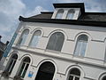
Sights include the Wendezoele farm museum, the “Noordmolen” water mill, the Twickel wood saw mill, the salt museum and the old and new Blasius Church .
Twickel Castle is located near the village . It can only be viewed from the outside because it is inhabited; the associated parks and forests are open to the public.
history
Delden has had city rights since 1333 . Delden was occupied by the Wehrmacht in May during the western campaign and liberated by Canadian troops on April 4, 1945.
photos

Old Blasius Church

Lock (kasteel twickel)

Water tower

Sculpture at the Keszthelyhof
Salt Museum


sons and daughters of the town
- Unico Wilhelm van Wassenaer (1692–1766), diplomat and composer
- Nicolaas van Wijk (1880–1941), German and Dutch scholar and father of Dutch Slavonic studies
Web links
Individual evidence
- ↑ a b Kerncijfers wijken en buurten 2017 Centraal Bureau voor de Statistiek , accessed on April 1, 2018 (Dutch)
- ↑ a b Welcome to Hof van Twente ( Memento from January 1, 2013 in the Internet Archive ).
- ^ The Battle of the Twente Canal . Canadian Heroes . Retrieved February 22, 2012. (English)