Deogarh (Uttar Pradesh)
| Deogarh | ||
|---|---|---|
|
|
||
| State : |
|
|
| State : | Uttar Pradesh | |
| District : | Lalitpur | |
| Location : | 24 ° 31 ' N , 78 ° 14' E | |
| Height : | 375 m | |
| Area : | 10.49 km² | |
| Residents : | 783 (2011) | |
| Population density : | 75 people / km² | |
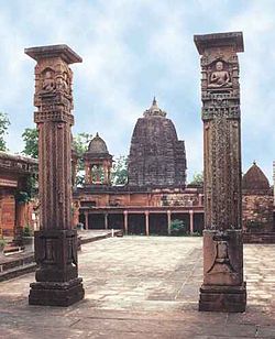
| Deogarh, Jain temple in the fort area | ||
Deogarh (देवगढ़) is a village with about 800 inhabitants in the Lalitpur district , a southern appendage of the Indian state of Uttar Pradesh , which was formerly part of the historic Bundelkhand region . In the mostly wooded cliffs above the river Betwa are the remains of a fortress ( hindi garh ; English fort ) as well as several historically and artistically significant temples and rock reliefs, which give the place a very special atmosphere.
location
The village of Deogarh is located in the immediate vicinity of steep cliffs above the Betwa River, about 31 km (driving distance) southwest of Lalitpur and can be reached from there by bus or taxi. The closest major city is Jhansi, about 127 km north .
population
The inhabitants of Deogarh are almost exclusively Hindus. As is usual in northern India, the male population is significantly higher than the female.
economy
The people of the village and its wooded area live largely self-sufficient from agriculture, which also includes a little cattle-raising (sheep, goats, chickens). Due to the remote location of Deogarh, tourism hardly plays a role.
history
The strategic location of Deogarh was recognized early on - at the latest since the Gupta period (4th – 6th centuries) the square was fortified and equipped with temples. At the end of the 11th century, the Chandellas , who lived in Khajuraho and Kanauj , briefly gained the upper hand over the place, which - due to its remote location - remained largely undestroyed in the time of the Islamic advance in northern India .
Attractions
- The Dashavatara Temple, which was probably built around 550 AD and dedicated to the Hindu god Vishnu , with its perfectly handcrafted exterior wall reliefs is one of the most important sights in India.
- Within the poorly preserved fortified area one is the Jain - Tirthankara Shantinatha temple dedicated, can be found in which also figures in other Jain prophets.
- Several figural reliefs have been carved out of the hard rock of the cliffs, most of which show figures from the Hindu pantheon of gods. A tour of around an hour accompanied by a local guide is highly recommended.
- Surroundings
- The small Kuraiya Bir temple (photo → Weblink) is about 2 km further north in the middle of a bush forest. It consists of a small vestibule ( mandapa ) with an adjoining cella ( garbhagriha ), which is topped by an unusual room surrounded by columns and pillars, but open on all sides and a shikhara- like tower structure. While the actual temple with its flat roofs, poorly structured outer walls and simple architectural decoration would still fit into the 6th century, the tower structure crowned by a ribbed stone ring ( amalaka ) seems to have been added later.
Web links
- Deogarh temple - Photos and information (English)


