Devil's Highway
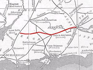
The Devil's Highway was a Roman road in England that connected Londinium ( London ) via Pontes ( Staines ) ![]() to Calleva Atrebatum (Silchester)
to Calleva Atrebatum (Silchester) ![]() . A bridge at Pontes may have crossed the Thames at Church Island
. A bridge at Pontes may have crossed the Thames at Church Island ![]() . At Calleva the road divided into three streets: the Port Way to Sorviodunum ( Old Sarum ), the Ermin Way to Glevum ( Gloucester ) and the road to Aquae Sulis( Bath ).
. At Calleva the road divided into three streets: the Port Way to Sorviodunum ( Old Sarum ), the Ermin Way to Glevum ( Gloucester ) and the road to Aquae Sulis( Bath ).
The stretch of road in London was rediscovered when Christopher Wren rebuilt St Mary-le-Bow in 1671-73 after the Great Fire of London . Modern excavations date their construction to the winter of 47 to 48 AD. Near London, the road was between 7.5 m and 8.7 m wide and covered with gravel. It has been repeatedly repaired. At least twice before the incursion of Boudicca in the years 60 or 61. The road ran straight from the Thames to what would later become Newgate![]() in the London Wall and then on through Ludgate Hill and the Fleet
in the London Wall and then on through Ludgate Hill and the Fleet ![]() . Then it split into Devil's Highway and the northwestern portion of Watling Street to Verulamium ( St Albans ).
. Then it split into Devil's Highway and the northwestern portion of Watling Street to Verulamium ( St Albans ).
See also
Individual evidence
- ↑ Lacey Wallace: The Origin of Roman London. P. 41. ( books.google.co.uk )
