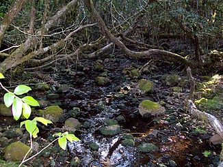
Dilgry River
| Dilgry River | ||
|
Dilgry River at an altitude of 1420 m with Antarctic beech ( Nothofagus moorei ) |
||
| Data | ||
| location | New South Wales , Australia | |
| River system | Manning River | |
| Drain over | Cobark River → Barrington River → Gloucester River → Manning River → Tasman Sea | |
| source | at Thunderbolt Lookout in Barrington Tops National Park 31 ° 55 ′ 7 ″ S , 151 ° 28 ′ 32 ″ E |
|
| Source height | 1440 m | |
| muzzle |
Cobark River east of Barrington Tops National Park Coordinates: 31 ° 55 ′ 27 " S , 151 ° 39 ′ 58" E 31 ° 55 ′ 27 " S , 151 ° 39 ′ 58" E |
|
| Mouth height | 339 m | |
| Height difference | 1101 m | |
| Bottom slope | 42 ‰ | |
| length | 26.1 km | |
The Dilgry River is a river in the east of the Australian state of New South Wales .
It rises in the northern part of Barrington Tops National Park below Thunderbolt Lookout . From there it flows east and flows into the Cobark River on the eastern border of the national park .
See also
Web links
Commons : Dilgry River - collection of pictures, videos and audio files
- List of Placenames ASSIGNED as RIVERs . Geographical Names Register (GNR) of NSW. Geographical Names Board of New South Wales (July 16, 2012 memento on the Internet Archive )
