Gloucester River
| Gloucester River | ||
|
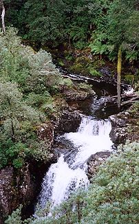
Gloucester Falls on the Gloucester River in Barrington Tops National Park |
||
| Data | ||
| location | New South Wales , Australia | |
| River system | Manning River | |
| Drain over | Manning River → Tasman Sea | |
| source | Gloucester Tops ( Barrington Tops ) 32 ° 4 ′ 59 ″ S , 151 ° 34 ′ 45 ″ O |
|
| Source height | 1190 m | |
| muzzle |
Manning River at Bundook coordinates: 31 ° 51 '44 " S , 152 ° 7' 2" O 31 ° 51 '44 " S , 152 ° 7' 2" O |
|
| Mouth height | 38.2 m | |
| Height difference | 1,151.8 m | |
| Bottom slope | 11 ‰ | |
| length | 102 km | |
| Left tributaries | Barrington River , Bowman River | |
| Right tributaries | Berrico Creek, Buggs Creek, Sandy Creek, Avon River | |
| Medium-sized cities | Gloucester | |
| Small towns | Faulkland, Bundook | |
The Gloucester River is a river in the east of the Australian state of New South Wales .
course
It rises in the rainforests of the Barrington Tops National Park with Antarctic beeches ( Nothofagus moorei ) and atherosperm . Further down, the river is flanked by trees of the subtropical rainforest, such as the red cedar ( Toona cilata ) and the Australian pink mahogany ( Dysoxylum fraserianum ).
Tributaries with mouth heights
- Berrico Creek - 155 m
- Buggs Creek - 135 m
- Sandy Creek - 112 m
- Avon River - 91 m
- Barrington River - 87 m
- Bowman River - 85 m
See also
Web links
Commons : Gloucester River - collection of images, videos and audio files
