
Dix-Huit Montagnes
| Dix-Huit Montagnes | |
|---|---|
  |
|
| Basic data | |
| Country | Ivory Coast |
| Capital | Man |
| surface | 16,600 km² |
| Residents | 1,284,657 (2007 estimate) |
| density | 77 inhabitants per km² |
| ISO 3166-2 | CI-MG |
Coordinates: 7 ° 24 ′ N , 7 ° 33 ′ W
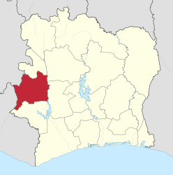
Dix-Huit Montagnes , in German "eighteen mountains", is a historical administrative region of the Ivory Coast with the capital Man .
population
According to an estimate from 2007, Dix-Huit Montagnes has approx. 1,284,657 inhabitants and thus a population density of 77 inhabitants per km² over an area of 16,600 km². The last census in 1988 counted 688,710 inhabitants.
geography
Dix-Huit Montagnes is in the west of the Ivory Coast and borders in the north with Bafing , in the east with Worodougou and Haut-Sassandra and in the south with Moyen-Cavally . To the west are Guinea and Liberia . The region is divided into the four departments Bangolo , Biankouma , Danané and Man .
swell
- ↑ World Gazetter ( Memento of the original from December 29, 2011 in the Internet Archive ) Info: The archive link was inserted automatically and has not yet been checked. Please check the original and archive link according to the instructions and then remove this notice.
Agnéby | Bafing | Bas-Sassandra | Denguélé | Dix-Huit Montagnes | Fromager | Haut-Sassandra | Lacs | Lagunes | Marahoué | Moyen-Cavally | Moyen-Comoé | N'Zi-Comoé | Savanes | Sud-Bandama | South Comoé | Vallée du Bandama | Vorodougou | Zanzan