
Bafing (region)
| Bafing | |
|---|---|
  |
|
| Basic data | |
| Country | Ivory Coast |
| Capital | Touba |
| surface | 9080 km² |
| Residents | 183,047 (2014 census) |
| density | 20 inhabitants per km² |
| ISO 3166-2 | CI-WR |
Coordinates: 8 ° 22 ′ N , 7 ° 36 ′ W
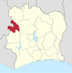
Bafing is an administrative region of the Ivory Coast with the capital Touba . Until 2011, the regions formed the highest administrative level in the country. Since then, the region has been subordinate to the Woroba district .
According to the 2014 census, 183,047 people live in the region.
The region consists solely of the Touba , Koro and Ouaninou departments .
Individual evidence
- ↑ Results of the 2014 census . Retrieved January 6, 2016.
Districts with regions: Bas-Sassandra : Nawa , San-Pédro , Gbôklé | Comoé : Indénié-Djuablin , Sud-Comoé | Denguélé : Folon , Kabadougou | Gôh-Djiboua : Gôh , Lôh-Djiboua | Lacs : N'zi , Iffou , Bélier , Moronou | Lagunes : Agnéby-Tiassa , Mé , Grands Ponts | Montagnes : Tonkpi , Cavally , Guémon | Sassandra-Marahoué : Haut-Sassandra , Marahoué | Savanes : Poro , Tchologo , Bagoué | Vallée du Bandama : Hambol , Gbêkê | Woroba : Béré , Bafing , Worodougou | Zanzan : Bounkani , Gontougou
Autonomous Districts: Abidjan | Yamoussoukro
Agnéby | Bafing | Bas-Sassandra | Denguélé | Dix-Huit Montagnes | Fromager | Haut-Sassandra | Lacs | Lagunes | Marahoué | Moyen-Cavally | Moyen-Comoé | N'Zi-Comoé | Savanes | Sud-Bandama | South Comoé | Vallée du Bandama | Vorodougou | Zanzan