
Abidjan (Autonomous District)
| Abidjan | |
|---|---|
  |
|
| Basic data | |
| Country | Ivory Coast |
| surface | 2119 km² |
| Residents | 4,707,404 (2014 census) |
| density | 2222 inhabitants per km² |
| founding | 2002 |
| ISO 3166-2 | CI-AB |
Coordinates: 5 ° 20 ′ N , 4 ° 2 ′ W

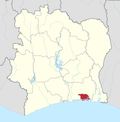
The Autonomous District of Abidjan is a district in the Ivory Coast in the south of the country on the Atlantic Ocean , which has replaced the municipality of Abidjan as an administrative unit since 2002 . The district now consists of ten independent parishes and four sub-prefectures. The ten parishes are summarized as the city of Abidjan.
The district largely borders the Lagunes district and has a short border with the Comoé district in the east. According to the 2014 census, the population of the ten municipalities together is 4,395,243, the total for the district is 4,707,404.
Structure of the district
Parishes of Abidjan Ville
Sub-prefectures
Individual evidence
- ↑ a b Results of the 2014 census . Retrieved January 10, 2016.
Districts with regions: Bas-Sassandra : Nawa , San-Pédro , Gbôklé | Comoé : Indénié-Djuablin , Sud-Comoé | Denguélé : Folon , Kabadougou | Gôh-Djiboua : Gôh , Lôh-Djiboua | Lacs : N'zi , Iffou , Bélier , Moronou | Lagunes : Agnéby-Tiassa , Mé , Grands Ponts | Montagnes : Tonkpi , Cavally , Guémon | Sassandra-Marahoué : Haut-Sassandra , Marahoué | Savanes : Poro , Tchologo , Bagoué | Vallée du Bandama : Hambol , Gbêkê | Woroba : Béré , Bafing , Worodougou | Zanzan : Bounkani , Gontougou
Autonomous Districts: Abidjan | Yamoussoukro