
Yamoussoukro (Autonomous District)
| Yamoussoukro | |
|---|---|
  |
|
| Basic data | |
| Country | Ivory Coast |
| surface | 3500 km² |
| Residents | 355,573 (2014 census) |
| density | 102 inhabitants per km² |
| founding | 2011 |
| ISO 3166-2 | CI-YM |
Coordinates: 6 ° 49 ′ N , 5 ° 16 ′ W
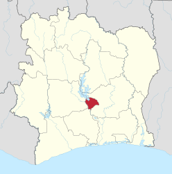
The Yamoussoukro Autonomous District is a district in the Ivory Coast in the center of the country that has existed since 2011. The district consists of two departments, each with two sub-prefectures, including the municipality of Yamoussoukro , which is also a sub-prefecture.
The district borders the Lacs , Gôh-Djiboua and Sassandra-Marahoué districts . According to the 2014 census, the population is 355,573.
Structure of the district
Sub-prefectures of the department of Yamoussoukro
Sub-prefectures of the Department of Attiégouakro
Web links
- District website (English and French)
Individual evidence
- ↑ a b Results of the 2014 census . Retrieved January 10, 2016.
Districts with regions: Bas-Sassandra : Nawa , San-Pédro , Gbôklé | Comoé : Indénié-Djuablin , Sud-Comoé | Denguélé : Folon , Kabadougou | Gôh-Djiboua : Gôh , Lôh-Djiboua | Lacs : N'zi , Iffou , Bélier , Moronou | Lagunes : Agnéby-Tiassa , Mé , Grands Ponts | Montagnes : Tonkpi , Cavally , Guémon | Sassandra-Marahoué : Haut-Sassandra , Marahoué | Savanes : Poro , Tchologo , Bagoué | Vallée du Bandama : Hambol , Gbêkê | Woroba : Béré , Bafing , Worodougou | Zanzan : Bounkani , Gontougou
Autonomous Districts: Abidjan | Yamoussoukro