
Dolmen from the Coll de les Portes
| Dolmen from the Coll de les Portes | |||
|---|---|---|---|
 Dolmen from the Coll de les Portes with a view of Cerbère |
|||
Location in the Pyrénées-Orientales department |
|||
| Coordinates | 42 ° 26 '48 " N , 3 ° 7' 25" E | ||
| place | Banyuls-sur-Mer , Pyrénées-Orientales , Occitania , France | ||
| Emergence | End of the Neolithic / beginning of the Bronze Age | ||
| height | 458 m | ||

The dolmen of the Coll de les Portes is a small gallery grave in the municipality of Banyuls-sur-Mer in the French department of Pyrénées-Orientales . In France, dolmen is the generic term for Neolithic megalithic structures of all kinds (see: French nomenclature ).
location
The dolmen is located in the southeast of the municipality of Banyuls-sur-Mer immediately west of the Coll de les Portes at 458.3 meters above sea level. The municipal boundary to Cerbère runs over the pass . The top of the pass is the northern extension of a ridge that descends from the Puig de Querroig (with Castell de Querroig ).
description
The dolmen of the Coll de les Portes is in poor condition, but can be assigned to a gallery grave with a trapezoidal chamber, like so many other dolmens on the north side of the Albères massif . The 1.5 × 1 meter and up to 20 centimeter thick cover plate and a larger orthostat on which the plate now rests are still preserved.
Photo gallery

General view of the dolmen

inside view

Cover plate
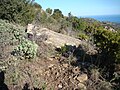
Oblique view looking northeast to the Mediterranean


See also
literature
- Abélanet, Jean: Itinéraires mégalithiques: dolmens et rites funéraires en Roussillon et Pyrénées north-catalanes . Canet: Trabucaire 2011, ISBN 978-2-84974-124-5 .
Individual evidence
- ↑ Carreras Vigorós, Enric and Tarrus Galter, Josep: 181 anys de recerca megalítica a la Catalunya Nord (1832-2012) . In: Annals de l'Institut d'Estudis Gironins, 54 . Girona: Institut d'Estudis Gironins 2013, p. 31-184 .