Elbe valley basin
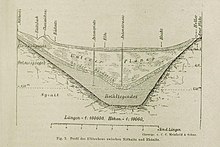
The (Dresden) Elbe valley basin (also: Dresden Elbe valley widening or often just Elbe valley (see Elbe valley definition )) is a 45 km long and 10 km wide widening of the Elbe valley between the cities of Pirna and Meißen , in which the city of Dresden is located.
geography
The Elbe valley basin is formed by the foothills and flanks of the Eastern Ore Mountains into the Lommatzscher Lösshügelland , those of the Lausitzer Bergland into the West Lusatian hills and mountains and the northwestern roof of Saxon Switzerland . He is geologically a fracture zone ( same zone ) is and will be the same as the main flow strongly meandering flows through. The region is climatically favored compared to the neighboring areas, so that viticulture is possible on the southern slopes of the mountains ( Saxon Wine Route ). In addition, there is intensive fruit growing . The valley climate is significantly drier (mean annual precipitation below 700 mm) and warmer (annual mean air temperature 8.5 ° C, in Dresden city center 10.4 ° C) than the climate in the surrounding highlands.
The Elbe valley is almost completely filled by the Dresden agglomeration , the most important cities are (listed in the direction of the Elbe):
|
View from the top station of the Dresden suspension railway to the Dresden Elbe valley
|
history
The area of the Elbe valley was populated at an early stage because of the fertile soils ( loess ) and the easy river crossing and was able to achieve a cultural and historical importance that is valued worldwide. The parts of the valley near the river were, in view of their cultural and scenic richness, as a world heritage site of the Dresden Elbe Valley as part of the UNESCO world cultural heritage .
During the GDR era, the boiler was jokingly called the Valley of the Unsuspecting , as West German television stations could only be received in it in the late 1980s, and then only in selected residential areas.
photos
View from Mordgrund in the Dresdner Heide over eastern parts of the city near the old town
View of Dresden from the Luisenhof on the northern slope of the Elbe
View from the spruce tower on the slope of the Plauen district to the south
Pillnitz : View from the "Leitenweg" over the "Royal Vineyard" into the Elbe Valley


