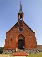
Drosedow (Wustrow)
|
Drosedow
Wustrow parish
Coordinates: 53 ° 14 ′ 22 ″ N , 12 ° 54 ′ 51 ″ E
|
|
|---|---|
| Residents : | 65 |
| Postal code : | 17255 |
| Area code : | 039828 |
Drosedow is a district of the municipality of Wustrow in the Mecklenburg Lake District ( Mecklenburg-Western Pomerania ).
geography
Drosedow lies at the confluence of the Drosedower Bek in the Gobenowsee and the Krummen Woklowsee . In the district of Drosedow there are also parts of the Rätzsee , the Kleine Emssee, the Große Emssee, the Peetschsee , the Heegessee and the Neu Drosedow settlement .
history
Drosedow was first mentioned in a document in 1347 and belonged to the Duchy of Mecklenburg-Strelitz . After the village was almost completely destroyed in the Thirty Years' War and all cattle had been driven away by the Swedes in 1675 , a tar furnace was built in 1713 , but it died in 1786. The first church in Drosedow was destroyed by a heavy storm in 1648. The second church is documented for the year 1734. Today's church is a Gothic brick building that was completed in 1882.
The manor house Drosedow is a bit away from the village and was owned by the von Mitzlaff family until 1945 . After the Second World War it was used as a refugee shelter.
Attractions
- Drosedow village church with Mitzlaff's mausoleum
- Mansion Castle Drosedow
- Manor's house
Web links
swell
- ^ Office Mecklenburgische Kleinseenplatte :: Wustrow. Retrieved October 30, 2017 .
- ↑ GeoPortal.MV: Home - GeoPortal Mecklenburg-Vorpommern. Retrieved October 30, 2017 .
- ^ Drosedow - The Mecklenburg small lake plate. Retrieved October 30, 2017 .
- ^ Drosedow Castle. Retrieved October 30, 2017 .
